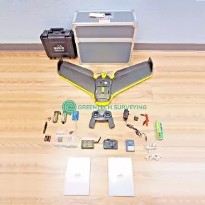
logo
  • Home
  • Product Categories
    XRF AnalyzersRobotic Total StationsGround Penetrating RadarGPS & GNSS SystemsDrones Surveying MappingCoordinate Measuring Machine3D Laser Scanners Pre-owned 3D Laser Scanners
  • Product Brands
    Trimble NavigationTopcon Positioning SystemsThermo ScientificSubsiteSokkiaProdimOlympusMalaLeica GeosystemsHilti CorporationGSSIGeoSLAMFAROCreaformArtec 3DAgEagle Aerial Systems Inc
  • Shipments & Returns
  • Payment Terms
  • About Us
  • Contact Us

Home

  1. Home
  2. AgEagle Aerial Systems Inc

AgEagle Aerial Systems Inc

Products

eBee Sensefly Drone Surveying Mapping UAS

eBee-Sensefly-Drone-Surveying-Mapping-UAS

$4,500

More Contact to buy

Product Categories

  • XRF Analyzers
  • Robotic Total Stations
  • Ground Penetrating Radar
  • GPS & GNSS Systems
  • Drones Surveying Mapping
  • Coordinate Measuring Machine
  • 3D Laser Scanners
  • Pre-owned 3D Laser Scanners

Product Brands

  • Trimble Navigation
  • Topcon Positioning Systems
  • Thermo Scientific
  • Subsite
  • Sokkia
  • Prodim
  • Olympus
  • Mala
  • Leica Geosystems
  • Hilti Corporation
  • GSSI
  • GeoSLAM
  • FARO
  • Creaform
  • Artec 3D
  • AgEagle Aerial Systems Inc
logo-footer
  • #89 Belilios Road, SG, 219924
  • +6562157934
  • sales@greentechsurveying.com
  • https://greentechsurveying.com
  • About Us
  • Payment Terms
  • Shipments & Returns
  • Contact Us

Product Categories

  • XRF Analyzers
  • Robotic Total Stations
  • Ground Penetrating Radar
  • GPS & GNSS Systems
  • Drones Surveying Mapping
  • Coordinate Measuring Machine
  • 3D Laser Scanners
  • Pre-owned 3D Laser Scanners

Product Brands

  • Leica Geosystems
  • Trimble Navigation
  • Topcon Positioning Systems
  • Sokkia
  • Artec 3D
  • GSSI
  • Hilti Corporation
  • FARO
  • GeoSLAM
  • Olympus

  • Creaform
  • Thermo Scientific
  • AgEagle Aerial Systems Inc
  • Subsite
  • Mala
  • Prodim

Copyright © Greentech Surveying, All rights reserved