
Description
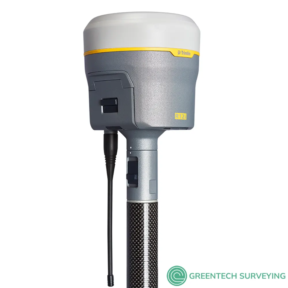
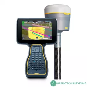
Trimble R12i GNSS Receiver for sale with Trimble ProPoint GNSS technology and new Trimble TIP tilt compensation, 8 mm H / 15 mm V RTK Precision, 672 GNSS channels, 2 cm H / 5 cm V Corrections, UHF Radio Wideband UHF radio. Brand new, factory sealed, 1 Year Trimble Warranty for parts and labor
The Trimble R12i delivers unmatched GNSS performance, speed and accuracy to boost your productivity like never before. With improved performance in challenging GNSS conditions and robust IMU-based tilt compensation that lets you forget about leveling the pole, you'll get more done faster than you thought possible.
NEW TRIMBLE TIP TILT COMPENSATION TECHNOLOGY
- IMU-based tilt compensation: Calibration-free Inertial Measurement Unit based tilt compensation with immunity to magnetic interference
- Reach hard to access points: Easily obtain accurate measurements on obstructed points like evidence under objects
- Stay out of harm's way: Safely capture points in dangerous locations like the side of a highway
- Built-in automatic integrity monitoring: Have total trust in your system with real-time IMU anomaly detection and alerts
- Watch the pole tip not the bubble: Be more aware of what's going on around you rather than staring at the level bubble when you take a measurement
MORE THAN 30% BETTER PERFORMANCE IN CHALLENGING ENVIRONMENTS*
- Accurate: A precise solution for repeatable results.
- Reliable: Real time error estimates in Trimble Forensics Capture that empower the officer.
- Productive: Faster convergence means less time spent measuring points in the field.
*In head-to-head testing with the Trimble R10-2 in challenging GNSS environments such as near and among trees, and built environments, the Trimble R12i receiver performed at least 30 percent better across a variety of factors, including time to achieve survey precision levels, position accuracy and measurement reliability
 TRIMBLE R12I FEATURES AT A GLANCE
- Trimble Inertial Platform (TIP) technology. Calibration-free and magnetically immune IMU-based tilt compensation for topo measurements and stakeout.
- Trimble ProPoint GNSS Technology: Superior performance in degraded GNSS conditions, with groundbreaking signal management that leverages the latest developments in GNSS signals and Trimble receiver hardware
- 672-channel solution with Trimble 360 satellite tracking technology
- Trimble TIP Tilt Compensation Technology: Inertial Measurement Unit (IMU) based tilt compensation for accurate laying out and measuring points without precisely leveling the pole
- Trimble CenterPoint RTX® Correction Service: Provides RTK level precision worldwide without the need for a base station or VRS network
- Trimble 360 Technology: 672 channels with support for all available and future GNSS signals, and improved protection from interference and spoofed signals
- Trimble xFill® Technology: Keeps you working in radio and cellular black spots with continuous RTK coverage
- Optimized for Trimble Access™ field software
- Android™ and iOS platform support
- Cellular, Bluetooth®, Wi-Fi data connectivity
- Military-spec rugged design and IP-67 rating
- Ergonomic form factor
- All day battery with built-in status indicator
- 6 GB internal memory
- Supports augmented reality capabilities through Trimble SiteVision™
*Challenging GNSS environments are locations where the receiver has sufficient satellite availability to achieve minimum accuracy requirements, but where the signal may be partly obstructed by and/or reflected off of trees, buildings, and other objects. Actual results may vary based on user's geographic location and atmospheric activity, scintillation levels, GNSS constellation health and availability, and level of multipath and signal occlusion
Trimble R12i Works With:
- Trimble TSC7
- Trimble TSC5
- Trimble T100
- Trimble T7
- Trimble TDC600
- Trimble Access
- Trimble Business Center Survey CAD software
Trimble SiteVision System Overview
Trimble SiteVision is a high accuracy augmented reality system that is ideal for use outdoors. It enables you to interact with your spatial data in the context of the real world. You can visualize and measure positions using GNSS and Augmented Reality technology as you explore the project site. The SiteVision app is supported on a number of Trimble devices powered by the Windows 10 operating system connected to a Trimble GNSS receiver, and on BYO devices powered by the Android™ operating system version 9.0 and later. This guide covers using the system on Trimble devices powered by the Windows 10 operating system.
The SiteVision system is an integrated positioning solution that works with GNSS and a device's camera. It requires:
- the SiteVision app running on one of the following Trimble devices, powered by the Windows 10 operating system:
- Trimble TSC7 controller / Trimble Ranger® 7 data collector / Spectra® Geospatial Ranger 7 data collector
- Trimble T7 tablet / Trimble Yuma® 7 tablet computer
- one of the following Trimble GNSS receivers, with tilt sensor technology, connected to the device via Bluetooth® technology:
- Trimble R12i GNSS receiver
- Trimble SPS986 GNSS Smart Antenna
To begin to use the system you will need a model that you want to visualize. The SiteVision system supports a wide range of model types including models of houses, commercial buildings, road designs, site designs, landscape plans, and utility services. It also supports the visualization of 2D data from GIS systems. The models can be created with a range of Trimble applications or many third party packages such as AutoCAD and ArcGIS.
| TRIMBLE INTEGRATED GNSS SYSTEMS COMPARATION | ||||
| Trimble R12i | Trimble R12 | Trimble R780 | Trimble R2 | |
| Max. Precision | 8 mm H/15 mm V | 8 mm H/15 mm V | 8 mm H/15 mm V | 10 mm H/20 mm V |
| Channels | 672 | 672 | 336 | 220 |
| Antenna | Integrated | Integrated | Integrated | Integrated |
| UHF Radio | Receive & Transmit | Receive & Transmit | Receive & Transmit | Receive |
| RTK Compatible | Yes | Yes | Yes | Yes |
| xFill | Yes | Yes | Yes | Yes |
| Memory | 6 GB | 6 GB | 9 GB | 48 GB |
| Cellular | Yes | Yes | External | External |
| Satellites | GPS, GLONASS, Galileo, BeiDou, NavIC, QZSS, SBAS | GPS, GLONASS, Galileo, BeiDou, NavIC, QZSS, SBAS | GPS, GLONASS, Galileo, BeiDou, NavIC, QZSS, SBAS | GPS, GLONASS, Galileo, BeiDou, SBAS |
| Additional Features | ProPoint, TIP Tilt Compensation | ProPoint | ProPoint, TIP Tilt Compensation | |

- 1. Challenging GNSS environments are locations where the receiver has sufficient satellite availability to achieve minimum accuracy requirements, but where the signal may be partly obstructed by and/or reflected off of trees, buildings, and other objects. Actual results may vary based on user’s geographic location and atmospheric activity, scintillation levels, GNSS constellation health and availability, and level of multipath and signal occlusion.
- 2. The current capability in the receivers is based on publicly available information. As such, Trimble cannot guarantee that these receivers will be fully compatible with a future generation of Galileo satellites or signals.
- 3. Precision and reliability may be subject to anomalies due to multipath, obstructions, satellite geometry, and atmospheric conditions. The specifications stated recommend the use of stable mounts in an open sky view, EMI and multipath clean environment, optimal GNSS constellation configurations, along with the use of survey practices that are generally accepted for performing the highest-order surveys for the applicable application including occupation times appropriate for baseline length. Baselines longer than 30 km require precise ephemeris and occupations up to 24 hours may be required to achieve the high precision static specification.
- 4. Network RTK PPM values are referenced to the closest physical base station.
- 5. May be affected by atmospheric conditions, signal multipath, obstructions and satellite geometry. Initialization reliability is continuously monitored to ensure highest quality.
- 6. TIP references the overall positioning error estimate at the tip of the surveying pole throughout the tilt compensation range. RTK refers to the estimated horizontal precision of the underlying GNSS position, which is dependent on factors that affect GNSS solution quality. The 5 mm constant error component accounts for residual misalignment between the vertical axes of the receiver and the built-in Inertial Measurement Unit (IMU) after factory calibration, assuming the receiver is mounted on a standard 2 m carbon fiber range pole which is properly calibrated and free from physical defects. The tilt-dependent error component is a function of the quality of the computed tilt azimuth, which is assumed here to be aligned using optimal GNSS conditions.
- 7. RMS performance based on repeatable in field measurements. Achievable accuracy and initialization time may vary based on type and capability of receiver and antenna, user’s geographic location and atmospheric activity, scintillation levels, GNSS constellation health and availability and level of multipath including obstructions such as large trees and buildings.
- 8. Accuracies are dependent on GNSS satellite availability. xFill positioning without an xFill Premium subscription ends after 5 minutes of radio downtime. xFill Premium will continue beyond 5 minutes providing the solution has converged, with typical precisions not exceeding 3 cm horizontal, 7 cm vertical. xFill is not available in all regions, check with your local sales representative for more information.
- 9. RTK refers to the last reported precision before the correction source was lost and xFill started.
- 10. Depends on SBAS system performance.
- 11. Receiver will operate normally to –40 °C, internal batteries are rated to –20 °C.
- 12. Tracking GPS, GLONASS and SBAS satellites.
- 13.. Varies with temperature and wireless data rate. When using a receiver and internal radio in the transmit mode, it is recommended that an external 6 Ah or higher battery is used.
- 14. Varies with terrain and operating conditions.
- 15. Due to local regulations, the integrated cellular modem cannot be enabled in China, Taiwan, or Brazil. A Trimble controller integrated cellular modem or external cellular modem can be used to obtain GNSS corrections via an IP (Internet Protocol) connection.
- 16. Bluetooth type approvals are country specific.
| TRIMBLE R12i GNSS RECEIVER TECHNICAL SPECIFICATIONS | ||
| Trimble R12i GNSS Receiver | ||
| Constellation agnostic, flexible signal tracking, improved positioning in challenging environments1 and inertial measurement integration with Trimble ProPoint GNSS technology | ||
| Increased measurement and stakeout productivity and traceability with Trimble TIP™ technology IMU-based tilt compensation | ||
| Advanced Trimble Custom Survey GNSS chips with 672 channels | ||
| Reduced downtime due to loss of radio signal or cellular connectivity with Trimble xFill technology | ||
| Signals tracked simultaneously | ||
| GPS: L1C, L1C/A, L2C, L2E, L5 GLONASS: L1C/A, L1P, L2C/A, L2P, L3 SBAS (WAAS, EGNOS, GAGAN, MSAS): L1C/A, L5 Galileo: E1, E5A, E5B, E5 AltBOC, E62 BeiDou: B1, B1C, B2, B2A, B3 QZSS: L1C/A, L1S, L1C, L2C, L5, L6 NavIC (IRNSS): L5 L-band: CenterPoint RTX |
||
| Iridium filtering above 1616 MHz allows antenna to be used up to 20 m away from iridium transmitter | ||
| Japanese LTE filtering below 1510 MHz allows antenna to be used up to 100 m away from Japanese LTE cell tower | ||
| Digital Signal Processor (DSP) techniques to detect and recover from spoofed GNSS signals | ||
| Advanced Receiver Autonomous Integrity Monitoring (RAIM) algorithm to detect and reject problem satellite measurements to improve position quality |
||
| Improved protection from erroneous ephemeris data | ||
| Positioning Rates | 1 Hz, 2 Hz, 5 Hz, 10 Hz, and 20 Hz | |
| POSITIONING PERFORMANCE | ||
| STATIC GNSS SURVEYING | ||
| High-Precision Static | ||
| Horizontal | 3 mm + 0.1 ppm RMS | |
| Vertical | 3.5 mm + 0.4 ppm RMS | |
| Static and Fast Static | ||
| Horizontal | 3 mm + 0.5 ppm RMS | |
| Vertical | 5 mm + 0.5 ppm RMS | |
| REAL TIME KINEMATIC SURVEYING | ||
| Single Baseline <30 km | ||
| Horizontal | 8 mm + 1 ppm RMS | |
| Vertical | 15 mm + 1 ppm RMS | |
| Network RTK | ||
| Horizontal | 8 mm + 0.5 ppm RMS | |
| Vertical | 15 mm + 0.5 ppm RMS | |
| RTK start-up time for specified precisions | 2 to 8 seconds | |
| TRIMBLE INERTIAL PLATFORM (TIP) TECHNOLOGY | ||
| TIP Compensated Surveying | ||
| Horizontal | RTK + 5 mm + 0.4 mm/° tilt (up to 30°) RMS | |
| Vertical | RTK + 5 mm + 0.4 mm/° tilt (up to 30°) RMS | |
| IMU Integrity Monitor | Bias monitoring | Temperature, age and shock |
| TRIMBLE RTX CORRECTION SERVICES | ||
| CenterPoint RTX | ||
| Horizontal | 2 cm RMS | |
| Vertical | 5 cm RMS | |
| RTX convergence time for specified precisions in Trimble RTX Fast regions | < 1 min | |
| RTX convergence time for specified precisions in non RTX Fast regions | < 15 min | |
| RTX QuickStart convergence time for specified precisions | < 1 min | |
| TRIMBLE XFILL | ||
| Horizontal | RTK9 + 10 mm/minute RMS | |
| Vertical | RTK9 + 20 mm/minute RMS | |
| TRIMBLE xFILL PREMIUM | ||
| Horizontal | 3 cm RMS | |
| Vertical | 7 cm RMS | |
| CODE DIFFERENTIAL GNSS POSITIONING | ||
| Horizontal | 0.25 m + 1 ppm RMS | |
| Vertical | 0.50 m + 1 ppm RMS | |
| SBAS | typically <5 m 3DRMS | |
| HARDWARE | ||
| PHYSICAL | ||
| Dimensions (W×H) | 11.9 cm x 13.6 cm (4.6 in x 5.4 in) | |
| Weight | 1.12 kg (2.49 lb) with internal battery, internal radio with UHF antenna, 3.95 kg (8.71 lb) items above plus range pole, Trimble TSC7 controller & bracket |
|
| Temperature | ||
| Operating | –40 °C to +65 °C (–40 °F to +149 °F) | |
| Storage | –40 °C to +75 °C (–40 °F to +167 °F) | |
| Humidity | 100%, condensing | |
| Ingress protection | IP67 dustproof, protected from temporary immersion to depth of 1 m (3.28 ft) | |
| Shock and vibration (Tested and meets the following environmental standards) | ||
| Shock | Non-operating: Designed to survive a 2 m (6.6 ft) pole drop onto concrete. Operating: to 40 G, 10 msec, sawtooth |
|
| Vibration | MIL-STD-810F, FIG.514.5C-1 | |
| ELECTRICAL | ||
| Power 11 to 24 V DC external power input with over-voltage protection on Port 1 and Port 2 (7-pin Lemo) Rechargeable, removable 7.4 V, 3.7 Ah Lithium-ion smart battery with LED status indicators Power consumption is 4.2 W in RTK rover mode with internal radio11 |
||
| Operating times on internal battery | ||
| 450 MHz receive only option | 6.5 hours | |
| 450 MHz receive/transmit option (0.5 W) | 6.0 hours | |
| 450 MHz receive/transmit option (2.0 W) | 5.5 hours | |
| Cellular receive option | 6.5 hours | |
| COMMUNICATIONS AND DATA STORAGE | ||
| Serial | 3-wire serial (7-pin Lemo) | |
| USB v2.0 | Supports data download and high speed communications | |
| Radio modem | Fully Integrated, sealed 450 MHz wide band receiver/transmitter with frequency range of 403 MHz to 473 MHz, support of Trimble, Pacific Crest, and SATEL radio protocols: |
|
| Transmit power | 2 W | |
| Range | 3–5 km typical / 10 km optimal | |
| Cellular | Integrated, 3.5 G modem, HSDPA 7.2 Mbps (download), GPRS multi-slot class 12, EDGE multi-slot class 12, Penta-band UMTS/HSDPA (WCDMA/FDD) 800/850/900/1900/2100 MHz, Quad-band EGSM 850/900/1800/1900 MHz, GSM CSD, 3GPP LTE |
|
| Bluetooth | Version 4.115 | |
| Wi-Fi | 802.11 b,g, access point and client mode, WPA/WPA2/WEP64/WEP128 encryption | |
| I/O ports | Serial, USB, TCP/IP, IBSS/NTRIP, Bluetooth | |
| Data storage | 6 GB internal memory | |
| Data format | CMR+, CMRx, RTCM 2.1, RTCM 2.3, RTCM 3.0, RTCM 3.1, RTCM 3.2 input and output | |
| 24 NMEA outputs, GSOF, RT17 and RT27 outputs, 1 PPS output | ||
| WEBUI | ||
| Offers simple configuration, operation, status, and data transfer | ||
| Accessible via Wi-Fi, Serial, USB, and Bluetooth | ||
| SUPPORTED CONTROLLERS & FIELD SOFTWARE | ||
| Trimble TSC7, Trimble T10, Trimble T7, Android and iOS devices running supported apps | ||
| Trimble Access 2019.10 or later | ||
| CERTIFICATIONS | ||
| FCC Part 15 (Class B device), 24, 32; CE Mark; RCM; PTCRB; BT SIG | ||