
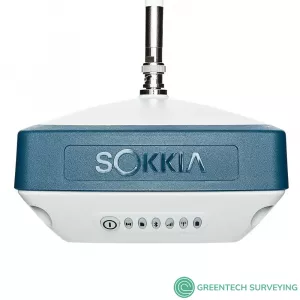

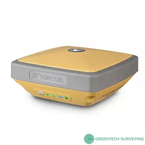
Description
Sokkia GRX3 GNSS Integrated Receiver, designed as a future-proof solution with Universal Tracking Channels technology that automatically tracks signals from all available and planned constellations, including GPS, GLONASS, and Galileo.
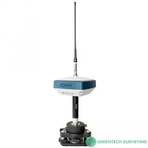
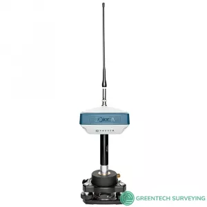
Sokkia multi-constellation GRX3 receiver is designed to provide a smaller, lighter and fully integrated GNSS solution. Can be used for GNSS post-processed surveying or RTK using wireless technologies.
- Provides smaller, lighter and fully integrated GNSS solution
- Multi-constellation receiver
- Offers complete and versatile solution for wide variety of precision applications
- Can be used for GNSS post-processed surveying, RTK using wireless technologies including network RTK option with cellular-equipped field computer, SiteComm RTK rover, or be paired with Sokkia total station for Fusion Positioning
- Provides advanced and powerful GNSS technology
- Features Sokkia Tilt technology which includes 9-axis inertial measurement unit (IMU) and ultra-compact eCompass designed to compensate for mis-leveled field measurements by as much as 15 degrees
- Future-proof solution with advanced GNSS chipset with Universal Tracking Channels technology that automatically tracks signals from all available and planned constellations, including GPS, GLONASS, Galileo, Beidou, IRNSS, QZSS, SBAS
- Meets IP67 certification for protection against harsh environmental weather conditions
Exceptional Versatility in a compact design: The Sokkia GRX3 is smaller, lighter, and packed with the most advanced GNSS technology in a design built to withstand the harshest field environments. All signals, all satellites and all constellations — in a compact, rugged design, with an integrated IMU and eCompass.
Sokkia Tilt Technology: Incorporates a revolutionary 9-axis inertial measurement unit (IMU) and ultra-compact eCompass, which compensate for mis-leveling up to 15 degrees.
- Sokkia Tilt Technology
- L Band Ready Technology
- 226 Universal Tracking Channels (GPS, GLONASS, Galileo, BeiDou, IRNSS, QZSS, SBAS)
- Integrated 400 MHz UHF and Sitecomm radios
- Fusion Positioning technology
Configuration Options
The Sokkia GRX3 Integrated GNSS Receiver is available in five kits. Please select your preference from the menu above.
- 1030634-01: GRX3 Base Kit
- 1030635-01: GRX3 Base & Rover Kit
- 1030632-01: GRX3 Network Rover Kit
- 1030632-01: GRX3 Rover Kit
- 1030631-01: GRX3 Static Single Kit
| Package | What's Included |
| Base Kit |
|
| Base & Rover Kit |
|
| Network Rover Kit |
|
| Rover Kit |
|
| Static Single Kit |
|
POSITIONING MADE EASY
This fully integrated all-in-view constellation RTK GNSS receiver brings a new level of versatility and flexibility into your precision positioning applications. The GRX3 provides unmatched usability and versatility that's sure to enhance your productivity. And like all Sokkia products, you can customize it to meet your needs and create your own workflows.
- Sokkia Tilt Technology
- L Band Ready Technology
- 226 Universal Tracking Channels covering all modernized signals (GPS, GLONASS, Galileo, BeiDou, IRNSS, QZSS, SBAS)
- Integrated 400MHz UHF and SiteComm Radios
- RTK and static survey operations
- Fusion Positioning technology automated workflow
- Standard RTK and Network RTK
- IP67 rated
 Sokkia Tilt Technology: The Sokkia GRX3 incorporates a revolutionary 9-axis inertial measurement unit (IMU) and an ultra-compact 3-axis eCompass. This advanced technology compensates for mis-leveled field measurements out of plumb by as much as 15 degrees. Awkward shots on steep slopes or hard to reach spots are now a breeze with tilt technology.
Open Architecture: The GRX3 architecture is designed so that third parties can write their own applications.
All Constellation Support: Featuring 226 Universal Tracking Channels with Universal Tracking Technology, the GRX3 has you covered. With programmable channels for tracking available signals, the GRX3 supports all modernized signals.
Multiple Wireless Technologies: The most commonly used wireless technologies can be integrated into the GRX3 receiver. Digital UHF, Network RTK and SiteComm.
Maximum Versatility: Utilizing full wireless connectivity and no voice feedback, the GRX3 enables the use of both RTK and network RTK technologies. It can be operated as both a private RTK base and RTK rover using the internal digital UHF
Stay in Control: The GRX3 includes built-in internal Bluetooth® capability that allows you to choose your field controller model and software. Whether it is a small palm-sized screen device, a larger screen handheld, or even a field laptop, the GRX3 is ready to connect.
Ready for the field: The GRX3’s magnesium alloy body can handle even the toughest job site conditions. It’s compact, watertight, and rugged with IP67 rated dust and water protection.
GeoPro Software: This is the simplest, most effective software suite for the geomatics and survey professional
GeoPro Field: Welcome to the quickest and easiest way to collect and layout points in the field. GeoPro Field’s user friendly interface and simple but powerful controls help you work faster and more precisely.
- Graphical interface available on Windows tablets
- Collect field measurements
- Control GNSS and robotic systems from Sokkia
- CAD in the field functionality
- Export point files to 3rd party software
GeoPro Office: Process field measurement data from a variety of sensors in the same job file. By combining data from multiple sensors, you get a more complete view of the project than you would with separate static files from each sensor
- Process raw data from field measurements
- Work with total station, digital level, and GNSS receiver data
- GNSS post-processing
- 3D CAD view (optional module)
- Road design tools (optional module)
| SOKKIA GRX3 GNSS RECEIVER TECHNICAL SPESIFICATIONS | |
| GNSS Tracking | |
| Channel Count | 226 with patented Universal Tracking Channels technology. |
| Signal | |
| GPS Signals | L1 C/A, L1C† L2C, L2P(Y), L5, L1C when signal available |
| GLONASS | L1 C/A, L1P, L2C/A, L2P, L3C, L3C when signal available |
| Galileo | E1/E5a/E5b/Alt-BOC |
| BeiDou/BDS | B1, B2 |
| IRNSS | L5 |
| SBAS | WAAS, EGNOS, MSAS, GAGAN (L1/L5), L5 when signal available. |
| L-band | TopNET Global D & C Corrections services |
| QZSS | L1 C/A, L1C, L1-SAIF, L2C, L5 |
| User Interface | |
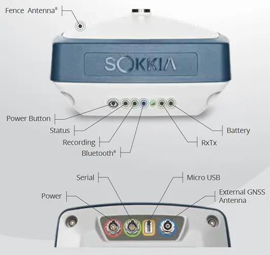
| Operation | Single-button operation for power, receiver reset, memory initialization |
| Display panel | 22 LED status indicators |
| Positioning Performance | |
| Static/Fast Static | H: 3 mm + 0.4 ppm V: 5 mm + 0.5 ppm* |
| Precision Static | H: 3.0 mm + 0.1 ppm V: 3.5 mm + 0.4 ppm |
| RTK | H: 5 mm + 0.5 ppm V: 10 mm + 0.8 ppm |
| RTK, Tilt Compensated |
H: 1.3 mm/°Tilt; Tilt ≤ 10° V: 1.8 mm/°Tilt; Tilt > 10° Maximum recommended angle for tilt compensation is 15°.** |
| DGPS | 0.25 m HRMS |
| L-Band, D Corrections Service |
H: < 0.1 m (95%) V: < 0.2 m (95%) |
| Memory | Internal Non-removable 8 GB SDHC |
| Environmental | |
| Dust/Water Rating | IP67 |
| Operating Temperature | -40ºC to 65ºC |
| Humidity | 100%, condensing |
| Drop and Topple | 1.0 m drop to concrete. 2.0 m pole drop to concrete |
| Physical | |
| Dimensions | 150 x 100 x 150 mm (w x h x d) |
| Weight | <1.15 kg |