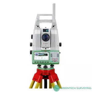

Description
The Leica Nova MS60, the world’s first self-learning MultiStation, enables you to perform all surveying tasks with one instrument.
The MS60 is a scanning total station that empowers complete data collection of individual points and large areas by leveraging sensor fusion and automation. Seamlessly integrated into Leica field and office surveying software, you can quickly complete your work on-site and offer a range of high-value deliverables.
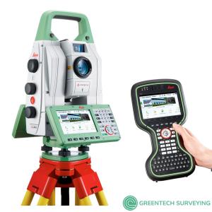
Be it settling, flexing, shifting, sliding or any other change of state – you will have it under control 24 hours a day, seven days a week. The TM60 comes with the world’s longest ATRplus range, half-second automatic aiming accuracy, advanced imaging and the longest continuous operation.
The instrument reveals its full potential when paired with the Leica GeoMoS monitoring solution. This combination enables you to react to complex demands of any monitoring project, be it continuous or periodic. The TM60 Monitoring Total Station is able to adapt automatically to changing environmental conditions, giving you peace of mind by reducing data gaps, downtime and unexpected costs.
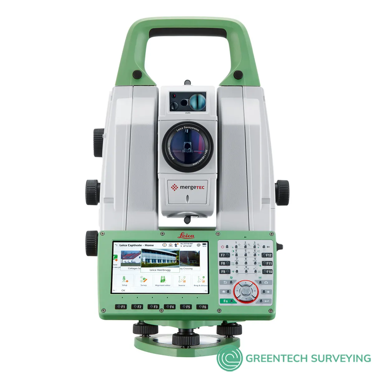
The instrument comes with the powerful and intuitive Leica Captivate onboard software. The easy-to-use touch technology and user-friendly apps enable the user to perform campaign monitoring.
When to use the Leica Nova TM60:
- Permanent monitoring (24/7): remote operation, continuous monitoring, real-time measurement data, robust against various environmental conditions.
- Campaign monitoring (periodical): flexible instrument setup, automated measurements, Leica Captivate field software, dedicated monitoring app, connectivity to cloud services.
- Buildings and structures: monitoring of buildings, skyscrapers, industrial and sports facilities, offshore and underground structures.
- Transportation infrastructure: monitoring of tunnels, railway, bridges, roads & highways, airports, ports & canals.
- Environmental monitoring: monitoring of landslides, rock falls, subsidence.
- Energy infrastructure: monitoring of dams, oil & gas, nuclear facilities, pipelines power plants.
- Mining: monitoring of slope stability, high walls and quarries.
FEATURES AND BENEFITS
- Highest-end total station: Highly accurate angle and distance measurements, robust design and easy-to-use apps. With improved automated functionalities, like Dynamic Lock and Autoheight, and the self-learning ARTplus features, the MS60 increases your efficiency, even in the most challenging conditions.
- 3D laser scanning: Scan up to 30,000 points per second (Hz) to complete your work quickly and get dense scanning grids. The MS60 features optimised scanning paths, including zenith scans, allowing you to significantly reduce the total scanning time.
- GNSS connectivity: GNSS is fully integrated in the workflow and the data structure, enabling direct georeferencing and increasing your flexibility in the field.
- Digital imaging: Digital imaging technology, including an overview and a 30x magnifying telescope camera, enables accurate image-assisted surveying both at the instrument and remotely, while also including extended image documentation.
- Highway monitoring enabled by patch scanning: The MS60 was an integral tool for monitoring a busy UK highway during tunnel construction underneath. Using the unique patch scanning feature and monitoring software, drivers could use the roadway while monitoring for movements ensured their safety.
- Innovations to the MS60: Learn how the MS60 scanning total station integrates the latest technologies to improve measurement potential across a broad range of applications from one our experts
- The payoff of a scanning total station: Successful U.S. company Titcomb Associates shares their experience integrating the MS60 into surveying workflows and the resulting safety and business benefits.
Integrated surveying, monitoring and CAD software
- Leica Captivate - the MS60’s onboard software with easy-to-use apps that cover all your surveying tasks. Includes a range of tools to optimise scanning tasks, like the Inspect Surface app and more.
- Leica Infinity - an intuitive surveying office software enabling seamless data transfer from the MS60 to the office to manage, process, analyse and quality check your field data.
- Leica GeoMoS - the automated deformation monitoring software providing movement analysis, reports and notifications
- Leica Cyclone - point cloud processing, management, collaboration and visualisation software.
- Leica Cloudworx - CAD plugins that allow you to work efficiently with large point clouds directly in your chosen CAD system
- Additional Hexagon packages and selected partner software
| LEICA NOVA MS60 DATA SHEET | ||
| ANGLE MEASUREMENT | ||
| Accuracy Hz and V | Absolute, continuous, quadruple | 1” (0.3 mgon) |
| DISTANCE MEASUREMENT | ||
| Range 2 / Accuracy / Measurement time | Prism (GPR1, GPH1P) Single (any surface) |
1.5m to >10,000m / 1mm + 1.5ppm / typ. 1.5s 1.5m to 2,000m / 2mm + 2ppm / typ. 1.5s |
| Measurement technology | Wave Form Digitising | Coaxial, visible red laser, dot size 8mm x 20mm @ 50m |
| SCANNING | ||
| Scan Rate / Maximum Scan Speed | 30.000 Hz | 30,000 points per second |
| Max. Range 7 / Range noise (1 sigma) | 30 kHz mode 8 kHz mode 1 kHz mode 1 Hz mode |
60m / 3mm @ 50m 150m / 1.5mm @ 50m 300m / 1.0mm @ 50m 1,000m / 0.6mm @ 50m |
| Scan data | 3D point cloud including true colour, intensity and signal-to-noise data | |
| Scan duration | Full dome scan 400gon x 155gon Band Scan 400gon x 50gon |
Resolution 50mm @ 15m, duration 12mins Resolution 12.5mm @ 50m, duration 45mins |
| IMAGING | ||
| Overview and telescope camera | Resolution / Frame rate Field of view (overview / telescope |
5 MPx CMOS / up to 20 fps 19.4° / 1.5° |
| MOTORISATION | ||
| Direct drives based on Piezo technology | Rotation speed / Time to change face | Maximum 400 gon (360°) per s / typically 2.9s |
| AUTOMATIC AIMING - ATRplus | ||
| Target aiming range2 / Target locking range2 | Circular prism (GPR1, GPH1P) 360° prism (GRZ4, GRZ122) |
1,500m / 1,000m 1,000m / 1,000m |
| Accuracy / Measurement time | ATRplus angle accuracy Hz, V | 1” (0.3 mgon) / typically 2.5s |
| POWERSEARCH | ||
| Range / Search time | 360° prism (GRZ4, GRZ122) | 300m / typically 5s |
| GUIDE LIGHT (EGL) | ||
| Working range / Accuracy | ||
| GENERAL | ||
| Operating system / Field software | Windows EC7 / Leica Captivate and its apps, supports onsite and realtime decisions | |
| Processor | TI OMAP4430 1GHz Dual-core ARM® Cortex™- A9 MPCore™ | |
| Autofocus telescope | Magnification / Focus Range | 30 x / 1.7m to infinity |
| AutoHeight Module | Distance accuracy Distance range |
1.0 mm (1 Sigma) 0.7 m to 2.7 m |
| Display and keyboard | 5“ (inch), WVGA, colour, touch, both faces | 37 keys, illumination |
| Operation | 3x endless drives, 1x Servofocus drive, 2x Autofocus keys, user-definable SmartKey | |
| Power management | Exchangeable Lithium-Ion battery | Up to 9h, internal charging capability |
| Data storage | EInternal memory / Memory card | 2 GB / SD card 1 GB or 8 GB |
| Interfaces | RS232, USB, Bluetooth®, WLAN | |
| Weight | MultiStation including battery | 7.7kg |
| Environmental specifications | Working temperature range Dust & Water (IEC 60529) / Blowing rain Humidity |
–20°C to + 50°C IP65 / MIL-STD-810G, Methods 506.5 I and 507.5 95%, non-condensing |