
Description
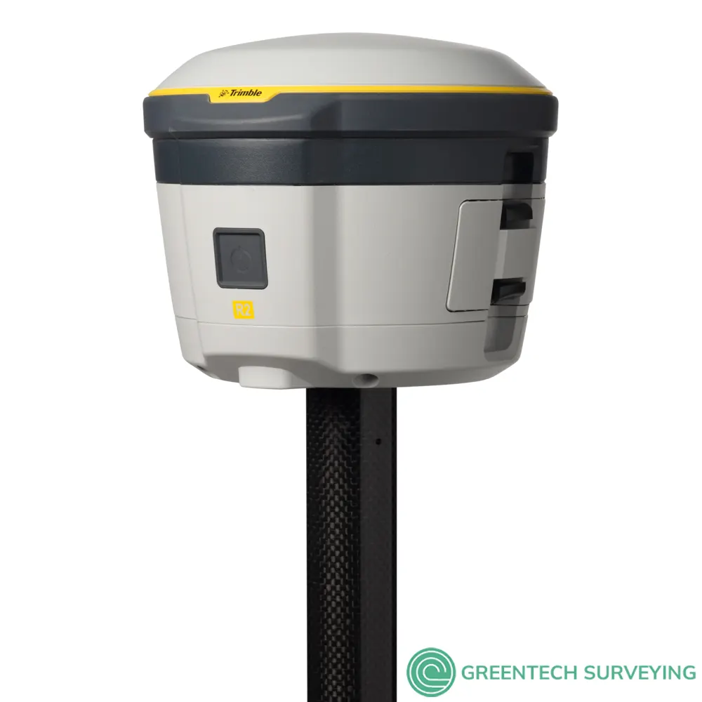
Trimble R2 Integrated GNSS System| Accuracy for your data. Versatility in the field. Flexibility for your workflow.
- 10 mm H/20 mm V Max. Precision
- 220 Channels
- Integrated Antenna
- Receive UHF Radio
The Trimble R2 is a compact, durable GNSS receiver that provides an easy-to-use solution for GIS and survey professionals who need to collect highly accurate data in a wide range of geospatial applications. Capable of delivering between submeter and centimeter positioning accuracy in real-time to any mobile device via a wireless Bluetooth® connection, the R2 receiver gives you total flexibility to choose a solution based on the accuracy and GNSS performance level that suits your application, letting you work the way you want.
- Professional solution for GIS & survey applications ranging from submeter to centimeter accuracies
- Easily collect data by pairing with devices such as smartphones, tablets or Trimble handhelds
- Fast to setup, easy-to-use, keeping you productive and focused on your work
- Supports multiple satellite constellations and correction sources for accurate data at any location
- Compact, cable-free design with integrated antenna
High accuracy for survey & GIS applications:
- Capable of delivering submeter to centimeter level positioning accuracy in real-time to suit any field data collection application.
- Achieve higher accuracy in real-time using correction sources from SBAS and VRS networks to Trimble RTX™ correction services*, delivered by either satellite or Internet, or via traditional RTK methods.
- Supports multiple satellite constellations and augmentation systems to provide maximum accuracy and positioning performance.
- * Trimble RTX™ available through Trimble applications
Flexible solution:
- Able to be paired with any mobile device on a variety of operating systems and platforms, from a Trimble handheld or controller to a modern smartphone or tablet.
- You can select the accuracy and GNSS performance level appropriate for your application.
- Capable of being operated either mounted on a pole, on a backpack or on a vehicle.
- Integrates with Trimble software such as Trimble Access™, Trimble TerraFlex™ and Trimble Business Center to enable data to be easily collected, communicated and processed, providing you with high-quality deliverables for your organization.
Simple, rugged system
- One-button start up and compact, streamlined design enables a quick setup.
- Built to withstand tough conditions meeting military specifications MIL-810G for ruggedness and an IP65 rating.
HIGH-ACCURACY GNSS DATA FOR GIS PROFESSIONALS…INSTANTLY
TRIMBLE R2 GNSS RECEIVER AND TRIMBLE TERRAFLEX SOFTWARE
Want to send an instant message? Don’t mail a letter; send a text. Want high-accuracy GNSS data in real time? Forget postprocessing; partner the Trimble TerraFlex™ mapping app with a Trimble R2 GNSS receiver.
IMPROVE YOUR GIS WITH HIGH-ACCURACY GNSS DATA
When it comes to GNSS positioning accuracy, the line between Survey and GIS is now blurred—the Trimble R2 GNSS receiver lets you collect positioning data in the field and use GNSS corrections services to enhance the data accuracy. The end result is centimeter-level accuracy in real time, right where you are. Without postprocessing.
You can’t achieve this accuracy with a GPS-enabled smartphone, nor with a consumer-grade receiver. And if lack of cellphone coverage is an issue, these devices usually can’t receive corrections via satellite.
But simply install the flexible Trimble R2 on a range pole, a GIS backpack, or even the roof of your car; connect to your data collector, and survey-grade GNSS positioning data is at your fingertips.
The Trimble R2’s compact, cable-free design with integrated antenna reduces equipment failures in the field.
It supports GNSS corrections from sources such as SBAS and VRS networks to Trimble RTX correction services, delivered by either satellite or Internet. For example, Trimble CenterPoint RTX (4 cm), Trimble FieldPoint RTX (10 cm), Trimble RangePoint RTX (30 cm), and Trimble ViewPoint RTX (<50 cm) correction services are available via IP or L-band.
SAVE TIME WITH REAL-TIME
The Trimble TerraFlex mapping app introduces smart, efficient workflows to save time and increase productivity. Collected data can be automatically sychronized to the Cloud. Even if you’re collecting data outside cell coverage, once you’re connected again the data can be automatically synced. Partnering TerraFlex software with the Trimble R2 receiver has enormous potential to transform your workflow, productivity, and results:
- Fewer steps for field crews: collection, correction, and sharing are now just one step, so the workflow is easier and faster, allowing crew to be vastly more productive.
- Fewer steps mean fewer opportunities to encounter problems and introduce errors.
- Finish jobs faster to meet deadlines, beat the weather or even the race against sundown.
- Sharing data with colleagues in real time enables teams to collaborate easily, and also enables data users to act on the information faster.
- Accurate data shared in real time lowers the risk of needing to repeat work
THERE’S A BETTER WAY
Until recently, collecting high-accuracy GNSS data was a multi-step process in the field and office: First, collect GNSS data on a handheld or other device. Then, return to the office and download the data to your desktop (plug in the cable first!). Import the data into your desktop software to refine GPS positions using static reference stations and, finally, share the information with colleagues.
But now there’s a better way.
The Trimble TerraFlex mobile mapping app with Trimble R2 GNSS receiver makes postprocessing a thing of the past. Simply collect accurate GNSS positions corrected in real time. Then, synchronize to the Cloud for immediate access by colleagues. One step; instant results. Save time, collaborate, and be more productive
| TRIMBLE R2 GNSS RECEIVER SPECIFICATIONS | |
| CONFIGURATION OPTION | |
| Type | Smart antenna |
| Base operation | Yes. Logging only |
| Rover operation | Yes |
| Rover position update rate | 1 Hz, 2 Hz, 5 Hz |
| Rover operation within a VRS Now network | Yes |
| MEASUREMENTS | |
|
|
| POSITIONING PERFORMANCE | |
| SBAS (WAAS/EGNOS/MSAS/GAGAN) Positioning | |
| Horizontal accuracy | ±0.50 m (1.6 ft) |
| Vertical accuracy | ±0.85 m (2.8 ft) |
| Code Differential GPS Positioning | |
| Correction type | DGPS RTCM 2.x |
| Correction source | .IBSS |
| Horizontal accuracy | ±(0.25 m + 1 ppm) RMS ±(0.8 ft + 1 ppm) |
| Vertical accuracy | ±(0.50 m + 1 ppm) RMS ±(1.6 ft + 1 ppm) |
| Static GNSS Positioning | |
|
Static and Fast Static
|
|
| Trimble RTX Positioning | |
CenterPoint RTX
|
|
| FieldPoint RTX™ | 10 cm Horizontal RMS |
| RangePoint® RTX | 30 cm Horizontal RMS |
| ViewPoint RTX | 50 cm Horizontal RMS |
| RTK Positioning2 | |
| Horizontal accuracy | 10 mm + 1 ppm RMS (0.033 ft + 1 ppm RMS) |
| Vertical accuracy | .20 mm + 1 ppm RMS (0.065 ft + 1 ppm RMS) |
| Network RTK2 | |
| Horizontal accuracy | 10 mm + 0.5 ppm RMS (0.033 ft + 0.5 ppm RMS) |
| Vertical accuracy | 20 mm + 0.5 ppm RMS (0.065 ft + 0.5 ppm RMS) |
| BATTERY AND POWER | |
| Internal | Replaceable internal battery 7.4 V, 2800 mA-hr, Lithium-ion |
| External | Power input on the Mini-B USB connector, non-charging as per the USB standard 10 W USB adapte |
| Power consumption | 4.95 W (VFD 100%), 3.7 W (VFD 12.5%) at 18 V, in rover mode |
|
Operation time on internal battery |
5 hours; varies with temperature |
| MECHANICAL | |
| User interface | LED indicators for receiver status On/Off key for one-button startup |
| Dimensions | 14.0 cm (5.5 in) diameter x 11.4 cm (4.5 in) height |
| Weight | 1.08 kg (2.38 lb) receiver only |
| ENVIRONMENTAL | |
|
Temperature
|
|
| Humidity | 100% condensing |
| Waterproof | IP65 |
| Pole drop | Designed to survive a 2 m (6.6 ft) drop onto all faces and corners onto concrete (25C) |
|
Shock
|
|
| Vibration | MIL-STD-810G (Operating), Method 514.6, Procedure I, Category 4, Figure 514.6C-1 (Common Carrier, US Highway Truck Vibration Exposure) Total Grms levels applied are 1.95 g |
| INTERNAL ANTENNA | |
| Frequency Range | L1/L2 (GPS, GLONASS, Galileo, BeiDou, QZSS), MSS (RTX), L1 SBAS |
| COMMUNICATIONS | |
| USB | 1 USB 2.0 (Type B) devicE |
| Wi-Fi | Simultaneous client and access point (AP) modes |
| Bluetooth wireless technology | Fully-integrated, fully-sealed 2.4 GHz Bluetooth module5 |
| Network protocols | HTTP (web browser GUI); NTP Server, TCP/IP or UDP; NTRIP v1 and v2, Client mode; mDNS/uPnP service discovery; dynamic DNS; eMail alerts; network link to Google Earth; PPP and PPPoE |
|
Supported data formats
|
|
| External GSM/GPRS modem, cell phone support | |
|
Integrated receiving radio (optional)
|
Integrated 450 MHz UHF Radio
|
| Data Storage | 48 MHB internal memory |
| CERTIFICATIONS | |
|
IEC 60950-1 (Electrical Safety); FCC OET Bulletin 65 (RF Exposure Safety); FCC Part 15.105 (Class B), Part 15.247, Part 90; Bluetooth SIG; IC ES-003 (Class B); Radio Equipment Directive 2014/53/EU, RoHS, WEEE; Australia & New Zealand RCM; Japan Radio and Telecom MIC |
|
TRIMBLE INTEGRATED GNSS SYSTEMS COMPARATION
| Trimble R10 | Trimble R8s | Trimble R2 | Trimble R1 | |
|---|---|---|---|---|
| Max. Precision | 8 mm Horizontal / 15 mm Vertical | 8 mm Horizontal / 15 mm Vertical | 10 mm Horizontal / 20 mm Vertical | 50 cm |
| RTK Compatible | Yes | Yes | Yes | No |
| Channels | 672 | 440 | 220 | 44 |
| Antenna | Integrated | Integrated | Integrated | Integrated |
| UHF Radio | Receive & Transmit | Receive & Transmit | Receive | -- |
| xFill | Yes | No | No | No |
| Memory | 6 GB | 56 MB | 48 MB | -- |
| Cellular | Yes | Available | External | External |
| Satellites | GPS, GLONASS, Galileo, BeiDou, SBAS | Based on configuration | GPS, GLONASS, Galileo, BeiDou, SBAS | GPS, GLONASS, SBAS, BeiDou, Galileo |
Documentations