Description
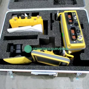
Selling used LEICA ICG60 Base Rover PERFORMANCE Performance Plus Smart Antenna Receiver with ANASONIC CC80. This item is in great working condition. There is a 90-day warranty and 30-day moneyback guarantee included.
Leica iCG60 Base/Rover Kit includes:
- 1x Leica iCON GPS 60 Performance Plus SmartAntenna Receiver
Internal Satel M3-TR1 Radio
UHF 403-473 MHz Rx/Tx Radio - 1x Leica GKL311 Single Bay Charger
- 1x Leica GAT2 Gainflex Radio Antenna
- 2x Leica Lithium-Ion GEB222 Battery
- 1x Leica GAD108 Extension Arm
- 1x Leica Transport Case
- Panasonic Toughpad Rugged CC80 7” Tablet
- 90-day warranty
- 30-day money back guarantee
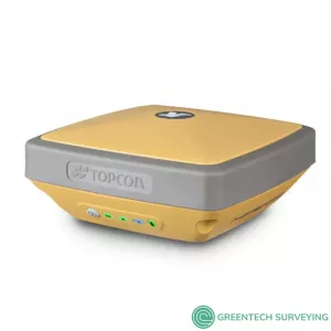
Leica iCON gps 60 is a versatile SmartAntenna for all construction positioning tasks. Featuring superior GNSS technology and various integrated communication options, it meets all your requirements for reliable and accurate measurements. Its intuitive display shows full status information of the instrument, simplifying operation and configuration. Leica iCON gps 60 also offers exceptional network capabilities allowing you to use RTK network services (Leica SmartNet and other networks) for highly reliable, improved GPS positions.
- Superior GNSS Technology for maximum accuracy and reliability.
Features Leica SmartTrack+ and SmartCheck+ and Leica xRTK. - Future-proof satellite tracking. Works with all existing and future satellite systems.
- SmartLink – bridges RTK communication gaps up to 10 minutes
- Multi-purpose GPS solution. Can be used as construction site GNSS Base, Rover or NetRover, in supervisor vehicle on site and entry level machine control mounted inside a machine to increase machine productivity
- Unique communication flexibility, featuring integrated radio, modem and Bluetooth.
- System integration made easy through use of platform independent SDK (Software Development Kit) bringing swift configuration to all
- Integrated NTRIP Server and Caster for Internet based Reference Station.
- No controller required for base station set-up means you need less hardware.
- Unique flexible software licencing and feature upgrade concept. You can order packages or individual licences when you need them, investing when you need to.
One instrument for many tasks:
- Perform many positioning tasks yourself, easily and quickly. Check grade or cut & fill, stake-out points and lines and as built check.
- Leica iCON gps 60 is the perfect mobile base station for your construction site. You don‘t need a controller for base station set-up. Stream corrections over the Internet without Radio.
- Save time and increase your productivity monitoring the grade from your supervisor vehicle on site.
- Use Leica iCON gps 60 for easy, single grade machine control applications, further increasing the value of the product and your investment.
Leica iCON GPS 60 Specification:
| GNSS PERFORMANCE | |
| GNSS technology | Leica patented SmartTrack+ technology:
|
| Number of channels | 555 channels |
| Maximum simultaneous tracked satellites | Up to 60 satellites simultaneously on two frequencies |
| Satellite signals tracking | GPS: L1, L2, L2C, L5 |
| GLONASS: L1, L2 | |
| Galileo (Test): GIOVE-A, GIOVE-B | |
| Galileo: E1, E5a, E5b, Alt-BOC | |
| BeiDou B1, B2 | |
| GNSS measurements | GPS: carrier phase full wave length, Code (C/A, P, C Code) |
| GLONASS: carrier phase full wave length, Code (C/A, P narrow Code) | |
| Galileo: carrier phase full wave length, Code | |
| BeiDou: carrier phase full wave length, Code | |
| Reacquisition time | < 1 sec |
| GNSS ANTENNA | |
| GNSS antenna options | Fully integrated GNSS antenna |
| External GNSS antenna connector (Type TNC) | |
| External GNSS antenna options | CGA100: GPS L1, L2, L2C, L5 |
| GLONASS: L1, L2, L3 | |
| Galileo: E1, E5a, E5b, E6, Alt-BOC | |
| BeiDou: B1, B2, B3 | |
| MEASUREMENT PERFORMANCE & ACCURACY | |
| Accuracy (rms) with real-time (RTK) | |
| Single baseline (< 30km) | Horizontal: 8 mm + 1 ppm (rms) |
| Vertical: 15 mm + 1 ppm (rms) | |
| Accuracy (rms) with post processing | |
| Static (phase) with long observations | Horizontal: 3 mm + 0.5 ppm (rms) |
| Vertical: 3.5 mm + 0.5 ppm (rms) | |
| Static and rapid static (phase) | Horizontal: 3 mm + 1 ppm (rms) |
| Vertical: 5 mm + 1 ppm (rms) | |
| On-the-fly (OTF) initialisation | |
| RTK technology | Leica SmartCheck+ technology |
| Reliability of OTF initialisation | 99,99% |
| Time for initalisation | Typically 4 sec |
| Network RTK | |
| Network technology | Leica SmartRTK technology |
| Supported RTK network solutions | iMAX, VRS, FKP |
| Supported RTK network standards | MAC (Master Auxiliary Concept) approved by RTCM SC 104 |
| HARDWARE | |
| Weight (iCG60) | 1450 g (3.19 lb) |
| Weight | 3200g (7,05 lb) Standard RTK Network Rover, incl. iCG60, CC80 Controller with Bracket, Pole, Battery |
| Dimensions | 197 x 197 x 130 mm (7,76 x 7,76 x 5,12 in) |
| Operating temperature | –40°C to +60°C (–40°F to +140 °F) |
| Storage temperature | –40°C to +85°C (–40°F to +185°F) |
| Humidity | 100%, compliance with ISO9022-12-04 and MIL STD 810F – 507.4-I |
| Proof against: water, sand and dust | IP67 according IEC60529 and MIL STD 810F – 506.4-I, MIL STD 810F – 510.4-I and MIL STD 810F – 512.4-I, Protected against blowing rain and dust, Protected against temporary submersion into water (max. depth 1 m) |
| Vibration | MIL-STD-810F, Figure 514.5C-3 |
| Shock | 40g - 6msec; compliance ISO 9022-31-06, No loss of lock to satellite signal when used on a pole set-up and submitted to pole bumps up to 150 mm |
| Drops | Withstands 1.2 m drop onto hard surfaces |
| Topple over | Withstands topple over from a 2m pole onto hard surfaces |
| Supply voltage | Nominal 24 V DC, Range 9.0 – 28 V DC |
| Power consumption | Typically 6 W |
| Internal power supply | 1x recharge & removable LI-Ion battery, 2.6 Ah, 4.4 Ah or 6.0 Ah / 7.4 V, fit into receiver |
| Internal power supply, operation time | 5:20 h receiving RTK data with standard radio |
| 4:40 h transmitting RTK data with standard radio | |
| 5:00 h RTK via built-in HSPA connection | |
| External power supply | Rechargeable external NiMh battery 9 Ah / 12 V; with voltage peak protection, Fullfils EN13309 |
| Certifications | Compliance to: FCC/IC Class B, CE, EN13309, RCM, ARIB STD-T66, RoHS, WEEE, ACPEIP |
| MEMORY & DATA RECORDING | |
| Internal memory | Built-in memory, 466 MB |
| Data capacity | 466 MB is typically sufficient for about GPS & GLONASS (8+4 satellites) 3’100 h raw data logging at 15 s rate |
| Type of data | Onboard recording of RINEX data |
| Recording rate | Up to 20 Hz |
| INTERFACE | |
| Buttons | ON / OFF button |
| 6 function buttons (arrow keys – up/down/left/right, Enter, Esc) | |
| Display | High resolution, 1.8” gray scale display with adjustable backlight:
|
| LED status indicator | 1x LED for detailed power status |
| Additional functionality | BasePilot functionality (stores up to different 100 base station locations and configurations for quick daily start up without user interaction) |
| COMMUNICATION | |
| Communication ports | 1x serial RS232 Lemo, PWR in, 12V PWR out |
| 1x USB Host | |
| 1x UART serial & USB (for removable internal RTK devices) | |
| 1x TNC for external GNSS Antenna | |
| 1x Bluetooth® port, Bluetooth® v2.00+ EDR, class 2 | |
| Number of simultaneous data links | Up to 3 real-time output interfaces via independent ports, providing identical or different RTK/RTCM formats |
| Built In data links | Radio modems:
|
| Radio modem antenna: External antenna connector (Type QN) | |
4G LTE / 3G DC-HSPA+ / HSPA+ / HSPA / UMTS (WCDMA):
|
|
| 4G LTE / 3G HSPA / UMTS / GSM cellular modem antenna: Integrated GSM / UMTS / HSPA / LTE antenna | |
| External data links | Radio modems: Support of any suitable serial RS232 UHF / VHF radios |
| Communication protocols | Real-time data formats for data transmission: Leica, Leica 4G, CMR, RTCM 3.1, RTCM 3.2 MSM 3 & 5 |
| Real-time data formats for data reception: Leica, Leica 4G, Leica Lite, CMR, CMR+, RTCM v2.3, RTCM 3.1, RTCM 3.2 MSMx 3 & 5 | |
| Web based protocol NTRIP: receive network corrections; built-in NTRIP Server and Caster to stream local corrections to multiple RTK rovers | |