Description
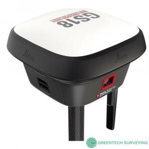
Leica GS18 I GNSS Smart Antenna RTK Rover with visual positioning, Imaging functionality, Tilt compensation redefines what an RTK rover is capable of
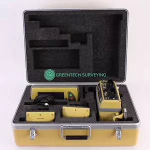
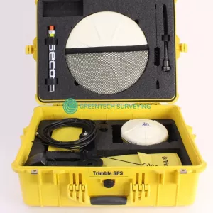
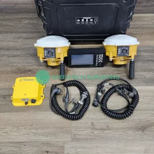
Package includes:
- Leica GS18 I LTE & UHF Performance
- GPS / GLONASS / Galileo / BeiDou / QZSS / SBAS
- HxGN SmartNet Pro1 / HxGN SmartNet+
- xGN SmartNet PPP
- Imaging functionality
- Tilt compensation
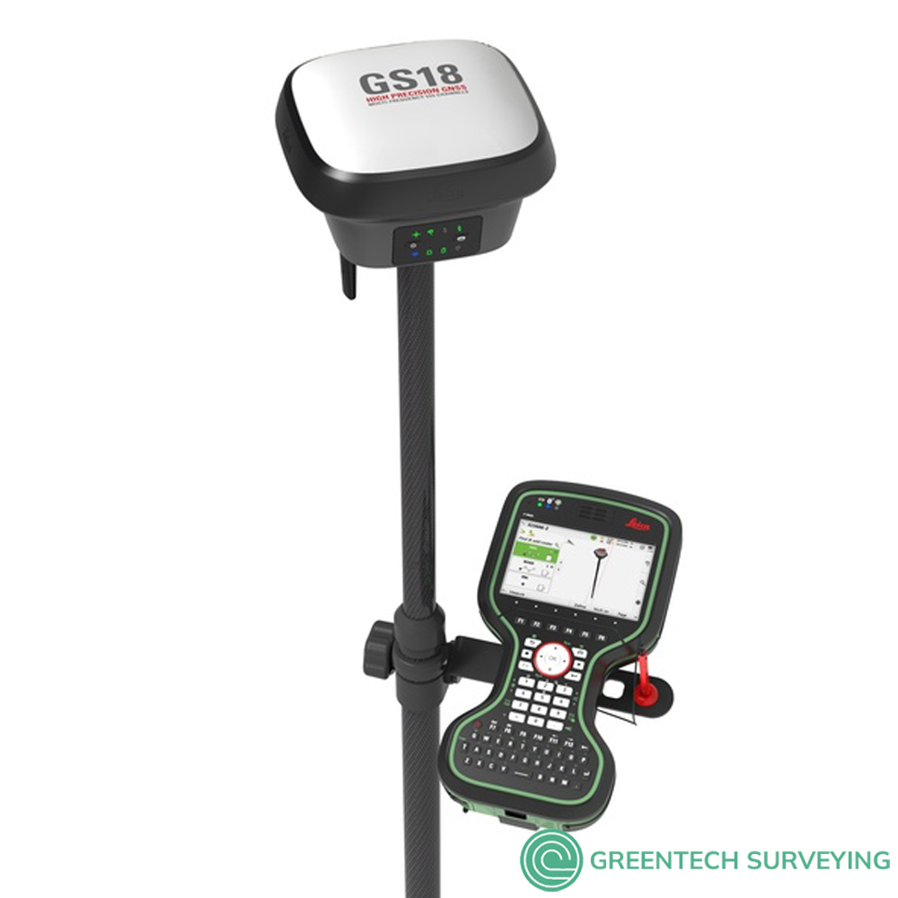
- Leica CS35 Data Field Controller Tablet
- GVP734 GNSS Rover Container
- GAT27 Antenna for LTE / radio
- GLS30, GNSS telescopic pole,carbon-fibre
- (2) GEB331 Battery int Li-Ion 11.1V/2800mAh
- Viva GNSS Commissioning
- LOP60, GS18 GLONASS option
- LOP61, GS18 Galileo option
- GKL341 Charger Prof 5000
- CS20 LTE Field Controller
- Leica Exchange CS20
- Leica Captivate Active Assist CS20
- Leica Captivate Measure Stake Line CS20
- Leica Captivate Measure & Stakeout CS20
- GHT66 Holder plate for CS20 controller
- GHT63 Pole clamp for attaching GHT
- MSD1000, SD memory card 1GB
- (2) GEB331 Battery int Li-Ion 11.1V/2800mAh
- 1 Year Viva GNSS (GS1X) SW Maint.
- 1 Year Captivate Customer Support
- 1 Year Viva GNSS Customer Support
- 1 Year CS20 Captivate SW Maint.
The Leica GS18 I is the world’s first GNSS smart antenna with visual positioning and Tilt compensation, redefines what an RTK rover is capable of.
Introducing Leica GS18 I, a versatile, survey-grade GNSS RTK rover with Visual Positioning. Designed for surveying professionals to measure points which previously could not be measured with a GNSS rover easily and accurately. Now, you can quickly capture the site in images and measure points from them, either in the field or later in the office. For GS18, I means imaging.
Sensor fusion of GNSS, IMU and a camera come together to create Visual Positioning technology, resulting in a GNSS RTK rover so powerful that it enables you to measure what you see. GS18 I has all the functionality of the Leica GS18 T: in addition to Visual Positioning, users can for example map points with either tilted or levelled pole.
- Measure points with obstructed view to the sky more efficiently and easily.
- Capture points you couldn’t reach before with a GNSS rover.
- Gain more flexibility and control, with no need to use additional time-consuming equipment.
- Map hundreds of points with survey-grade accuracy within minutes.
- Capture the scene quickly and decide later, what should be measured – even if the scene subsequently changes or disappears.
- Tap on an image to measure a point in the field or in the office.
- Quick and thorough so you catch every detail.
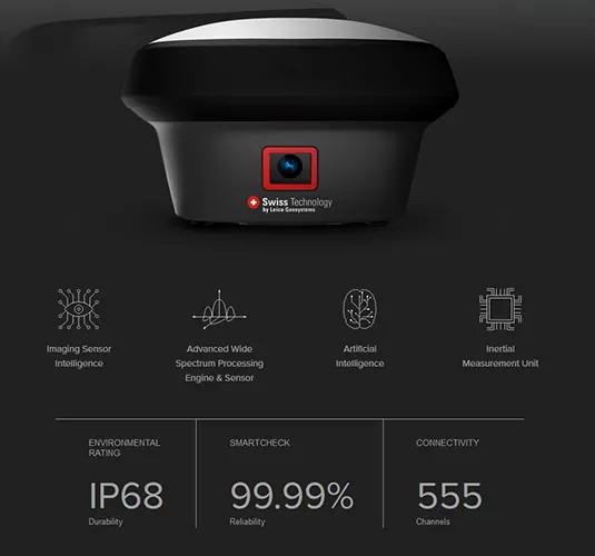
Visual Positioning: The GS18 I matches the same intelligent tilt technology of the GS18 T and the advanced signal tracking capabilities of the smartest GNSS antennas—but the GS18 I takes another step forward in technological innovation. With the new addition of an imaging sensor, the GS18 I lets you perform photogrammetric measurements on the fly. Its cutting-edge implementation of sensor fusion empowers you to take your efficiency to a whole new level and at the same time overcome traditional GNSS obstacles such as measuring under a building canopy, dealing with multipathing and even performing vertical measurements of facades, all without resorting to costly alternative measurement options or putting yourself in harm’s way.
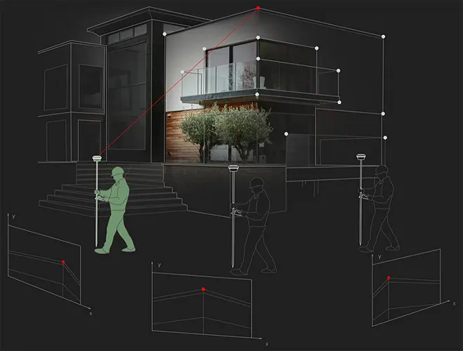
- A PICTURE IS FASTER THAN A POLE CAN MEASURE: The GS18 I captures images at a frequency of 2 Hz while the operator walks. Those images are processed in real-time and can be used for measuring points immediately after capture stops. Points can then be measured with a simple click. It’s that easy. And in case you are back in the office and discover you need more measurements, all you have to do is use your imagery, no need to return to the field.
- Overcoming ChallEnges: Traditional challenges call for modern measures. Often inaccessible points such as across a busy street, behind a gate or in dangerous areas, is where the GS18 I shines. But also in places with GNSS signal obstruction (e.g. under a roof, balcony or tree). Or having to measure points on a facade of a building (e.g. corners of a window and height of the roof) have all become much easier.
- 3D Visualization: 3D point clouds can be a powerful tool to help team members visualize and collaborate more effectively. With the new GS18 I, you will be able to easily do just that.
- Survey-Grade Accuracy: With the use of the GS18 I’s sensor fusion, it is able to achive survey grade accuracies while measuring from images
- Insights: Be inspired by the success of other surveyors and discover how to maximize quality, efficiency and productivity.
- CAPTIVATE: Companies often can get lost in the race to add features while forgetting about the most important element, you. With Captivate, we focused on bringing back the human side to technology.
- LEICA ACTIVE ASSIST: Solve your problems in the field with the help of our support team that can remotely access your device and assist with any needs in the field
- LEICA EXCHANGE: Easily and seamlessly sync your data with the office for an efficient and easy workflow.
Designed for surveying professionals to measure points which previously could not be measured with a GNSS rover easily and accurately. Now, you can quickly capture the site in images and measure points from them, either in the field or later in the office.
Sensor fusion of GNSS, IMU and a camera come together to create Visual Positioning technology, resulting in a GNSS RTK rover so powerful that it enables you to measure what you see. GS18 I has all the functionality of the Leica GS18 T: in addition to Visual Positioning, users can for example map points with either tilted or levelled pole.
- INNOVATIVE: GS18 I is an accurate and easy to use GNSS RTK Rover. It utilises highly innovative Visual Positioning technology based on seamless integration of GNSS, IMU and a camera. It enables you to measure points in survey-grade accuracy from images either in the field or in the office. Alternatively, create point clouds from captured images using Leica Infinity to expand possibilities even further.
- FAST: Designed to measure a large number of points efficiently. The GS18 I allows you to capture images and measure hundreds of points within minutes with no need to physically reach the point. Time spent on-site is reduced and revisits minimised - once the site is captured, you can measure all detail whenever you want to.
- VERSATILE: Imaging power has changed the rules of the game. By having the power to measure what you see, you can now reach places you couldn’t before without the need to switch tools or climb through obstacles. This gives you flexibility in the field, frees up equipment and crews, truly maximises productivity, and increasing profits.
- ENGAGING SOFTWARE: The Leica Captivate field software is the perfect companion for the GS18 I. With easy-to-use apps, all measured and design data can be viewed and used, providing you with a clear understanding of your data in 2D and 3D view. Captivate spans industries and applications with little more than a simple tap, regardless of whether you work with GNSS, total stations or both.
- TILT COMPENSATION: Based on sensor fusion of IMU and GNSS, GS18 I’s tilt compensation is immune to magnetic disturbances and it works immediately without calibration. With the GS18 I, surveyors have the flexibility to measure points with a levelled pole and still save the tilt values of each measurement. That way you have the trust that what was measured, is correct.
- INTERNAL MEMORY: Users with any GS18 model have the flexibility to log raw data into an SD card or the internal memory.
- 4G LTE & EXCELLENT MEASUREMENT QUALITY: Tracking multi-frequency signals comes as standard with all Leica Geosystems GS sensors. Combined with an excellent GNSS antenna element and a position update rate of 20 Hz, GS18 I ensures reliable measurement quality
- IMPROVED PERFORMANCE: Multipath reduction and interference mitigation options in Captivate boost GNSS signal tracking quality under harsh environments, which improves RTK availability and accuracy. Also, an interference toolkit will enable filtering to remove in- and out-of-band distortions for even more robust GNSS signal tracking
- ACTIVE CUSTOMER CARE: Through Active Customer Care (ACC), a global network of experienced professionals is only a click away to guide you through any challenge. Control your costs with a Customer Care Package (CCP) which gives you peace of mind you are covered anywhere, anytime.
| LEICA GS18 I GNSS RTK ROVER TECHNICAL SPECIFICATIONS | ||
| GNSS TECHNOLOGY & SERVICES | ||
| Self-learning GNSS | Leica RTKplus | Adaptive on-the-fly satellite selection |
| HxGN SmartNet Global | HxGN SmartNet Pro | Network RTK and unlimited worldwide RTK bridging and PPP service |
| HxGN SmartNet+ | Network RTK and RTK bridging service | |
| HxGN SmartNet PPP | Unlimited worldwide RTK bridging and PPP service | |
| Leica SmartCheck | ontinuous check of RTK solution | Reliability 99.99% |
| Signal tracking | GPS | GLONASS | L1, L2, L2C, L5 | L1, L2, L2C, L3 |
| Galileo | BeiDou | E1, E5a, E5b, AltBOC, E6 | B1I, B1C, B2I, B2a, B3I | |
| QZSS | NavIC | L1, L2C, L5, L62 | L53 | |
| SBAS | TerraStar | WAAS, EGNOS, MSAS, GAGAN | L-Band, IP | |
| RAIM | Receiver Autonomous Integrity Monitoring | Detection and elimination of faulty satellite signals for enhanced positioning solution and GNSS integrity |
| Number of channels | 555 (more signals, fast acquisition, high sensitivity) | |
| Tilt compensation | Increased measurement productivity and traceability | Calibration-free Immune to magnetic disturbances |
| IMAGING | ||
| Measuring camera | Sensor | Field of view | Video frame rate | Global shutter with 1.2 MP | Hz 80°, V 60° | 20 Hz |
| Image group capture | 2 Hz capturing rate | Max. capturing time: 60 s, size of an image group appr. 50 MB |
| Point cloud | Leica Infinity software | Derive point clouds from image groups |
| MEASUREMENT PERFORMANCE & ACCURACY | ||
| Time for RTK initialisation | Typically 4 s | |
| Real-time kinematic (Compliant to ISO17123-8 standard) |
Single baseline Network RTK |
Hz 8 mm + 1 ppm | V 15 mm + 1 ppm Hz 8 mm + 0.5 ppm | V 15 mm + 0.5 ppm |
| Real-time kinematic tilt compensated | Not for static control points | Additional Hz uncertainty max 8 mm + 0.4 mm/° tilt down to 30° tilt |
| RTK bridging | Up to 10 min bridging of RTK outages | Hz 2.5 cm | V 5 cm |
| PPP | Initial convergence to full accuracy typically 10 min, Re-convergence < 1 min |
Hz 2.5 cm | V 5 cm |
| Post processing | Static (phase) with long observations Static and rapid static (phase) |
Hz 3 mm + 0.1 ppm | V 3.5 mm + 0.4 ppm Hz 3 mm + 0.5 ppm | V 5 mm + 0.5 ppm |
| Code differential | DGNSS | Hz 25 cm | V 50 cm |
| Image point measurement | 1-click measurement in field & office | Typically 2 cm – 4 cm (2D1) captured from 2 – 10 m distance |
| COMMUNICATIONS | ||
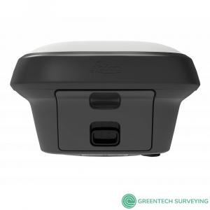
| Communication ports | Lemo | Bluetooth® | WLAN | USB and RS232 serial | Bluetooth® v4.0 (BLE & BR/EDR), class 1.5 | 802.11 b/g/n for field controller communication only |
| Communication protocols | RTK data protocols NMEA output Network RTK |
Leica 4G, Leica, CMR, CMR+, RTCM 2.2, 2.3., 3.0, 3.1, 3.2 MSM NMEA 0183 v4.00 & v4.10 and Leica proprietary VRS, FKP, iMAX, MAC (RTCM SC 104) |
| Built-in 4G LTE modem4 | LTE frequency bands UMTS frequency bands GSM frequency bands |
20, 8, 3, 1, 7 | 13, 17, 5, 4, 2 | 19, 3, 1 8, 3, 1 | 5, 4, 2 | 6, 19, 1 900, 1800 | 850, 900, 1800, 1900 MHz |
| Built-in UHF modem5 | Receive & transmit UHF radio modem | 403 – 473 MHz, channel spacing 12.5 kHz, 20 kHz, 25 kHz, max. 1 W output power up to 28800 bps over air | 902 – 928 MHz (licence free in North America), max 1 W output power |
| GENERAL | ||
| Field controller and software | Leica Captivate software | Leica CS20 LTE or BASIC field controller, Leica CS30 & CS35 tablets |
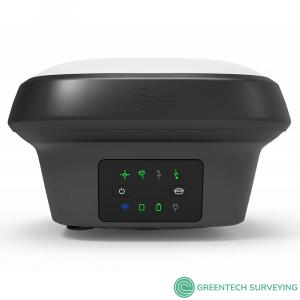
| User interface | Buttons and LEDs Web server |
On / Off and Function button, 8 status LEDs Full status information and configuration options |
| Data recording | Storage Data type and recording rate |
Internal memory up to 4 GB, Removable SD card Leica GNSS raw data and RINEX data at up to 20 Hz |
| Power management | Internal power supply External power supply Operating time6 |
IExchangeable Li-Ion battery (2.8 Ah / 11.1 V) Nominal 12 V DC, range 10.5 – 26.4 V DC Typical time up to 8 h |
| Weight and dimensions | Weight | Dimensions | 1.25 kg / 3.55 kg standard RTK rover setup on pole | 173 mm x 173 mm x 109 mm |
| Environmental | Temperature Drop Proof against water, sand and dust Vibration Humidity Functional shock |
-30 to +50°C operating with camera, -40 to +65°C operating without camera, -40 to +85°C storage Withstands topple over from a 2 m survey pole onto hard surfaces IP66 | IP68 (IEC60529 | MIL STD 810G CHG-1 510.6 I | MIL STD 810G CHG-1 506.6 II, MIL STD 810G CHG-1 512.6 I) Withstands strong vibration (ISO9022-36-08 | MIL STD 810G 514.6 Cat.24) 95% (ISO9022-13-06 | ISO9022-12-04 | MIL STD 810G CHG-1 507.6 II) 40 g / 15 to 23 msec (MIL STD 810G 516.6 I) |
| Leica Geosystems GNSS Comparison Chart | |||||||||||||||||||||||||||||||||||||||||
 |
 |
 |
 |
 |
 |
||||||||||||||||||||||||||||||||||||
| Signal tracking |
Dual-frequency
|
Dual-frequency
|
Multi-frequency
|
Multi-frequency
|
Multi-frequency
|
Multi-frequency
|
|||||||||||||||||||||||||||||||||||
|
|
|
|
|
|
|
|||||||||||||||||||||||||||||||||||
|
|
|
|
|
|
|
|||||||||||||||||||||||||||||||||||
| Tilt compensation |
 |
|
|
 |
|
|
|||||||||||||||||||||||||||||||||||
| Single baseline RTK |
Hz 10 mm + 1 ppm / V 20 mm + 1 ppm
|
Hz 8 mm + 1 ppm / V 15 mm + 1 ppm
|
Hz 8 mm + 1 ppm / V 15 mm + 1 ppm
|
Hz 8 mm + 1 ppm / V 15 mm + 1 ppm
|
Hz 8 mm + 1 ppm / V 15 mm + 1 ppm
|
Hz 8 mm + 1 ppm / V 15 mm + 1 ppm
|
|||||||||||||||||||||||||||||||||||
| Network RTK |
Hz 10 mm + 0.5 ppm / V 20 mm + 0.5 ppm
|
Hz 8 mm + 0.5 ppm / V 15 mm + 0.5 ppm
|
Hz 8 mm + 0.5 ppm / V 15 mm + 0.5 ppm
|
Hz 8 mm + 0.5 ppm / V 15 mm + 0.5 ppm
|
Hz 8 mm + 0.5 ppm / V 15 mm + 0.5 ppm
|
Hz 8 mm + 0.5 ppm / V 15 mm + 0.5 ppm
|
|||||||||||||||||||||||||||||||||||
| Static (phase) with long observations |
Hz 3 mm + 0.5 ppm / V 6 mm + 0.5 ppm
|
Hz 3 mm + 0.1 ppm / V 3.5 mm + 0.4 ppm
|
Hz 3 mm + 0.1 ppm / V 3.5 mm + 0.4 ppm
|
Hz 3 mm + 0.1 ppm / V 3.5 mm + 0.4 ppm
|
Hz 3 mm + 0.1 ppm / V 3.5 mm + 0.4 ppm
|
Hz 3 mm + 0.1 ppm / V 3.5 mm + 0.4 ppm
|
|||||||||||||||||||||||||||||||||||
| Static and rapid static (phase) |
Hz 5 mm + 0.5 ppm / V 10 mm + 0.5 ppm
|
Hz 3 mm + 0.5 ppm / V 5 mm + 0.5 ppm
|
Hz 3 mm + 0.5 ppm / V 5 mm + 0.5 ppm
|
Hz 3 mm + 0.5 ppm / V 5 mm + 0.5 ppm
|
Hz 3 mm + 0.5 ppm / V 5 mm + 0.5 ppm
|
Hz 3 mm + 0.5 ppm / V 5 mm + 0.5 ppm
|
|||||||||||||||||||||||||||||||||||
| Reliability |
99,95%
|
99,95%
|
99,95%
|
99,95%
|
99,95%
|
99,95%
|
|||||||||||||||||||||||||||||||||||
|
|
|
|
|
|
|
|||||||||||||||||||||||||||||||||||
|
|
|
|
|
|
|
|||||||||||||||||||||||||||||||||||
| RTK reference station functionality |
|
|
|
|
|
|
|||||||||||||||||||||||||||||||||||
| Cellular / UHF Radio (receive & transmit) modem |
Controller internal
|
3G
|
3G
|
4G
|
3G
|
3G
|
|||||||||||||||||||||||||||||||||||
| Storage |
Controller internal
|
MicroSD card
|
MicroSD card
|
SD card
|
SD card
|
SD card
|
|||||||||||||||||||||||||||||||||||
|
|
|
|
|
|
|
|||||||||||||||||||||||||||||||||||
| Power, Bluetooth®, USB, RS232 |
|
|
|
|
|
|
|||||||||||||||||||||||||||||||||||
| Event, PPS |
|
|
|
|
|
|
|||||||||||||||||||||||||||||||||||
| Operating temperature -40°C to 65°C |
|
|
|
|
|
|
|||||||||||||||||||||||||||||||||||
| IP68 proof against water, sand and dust |
|
|
|
|
|
|
|||||||||||||||||||||||||||||||||||
| Weight (without battery) |
0.60 kg
|
0.93 kg
|
0.93 kg
|
1.20 kg
|
1.20 kg
|
1.84 kg
|
|||||||||||||||||||||||||||||||||||