


Description
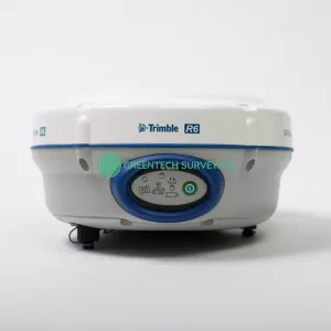
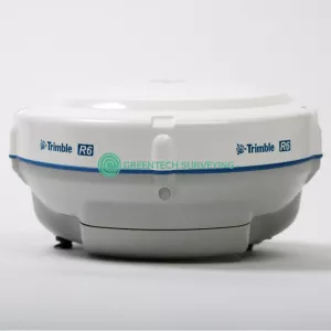
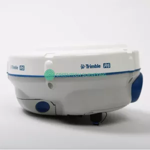
Up for sale used Trimble R6 Model 4 Receiver has a 450-470MHz radio, 220 channel systems with R-Track satellite technology. GNSS, L2C, L5 and GLONASS Satellites. Upgradeable to transmit radio. All in great used condition and everything has been thoroughly tested.
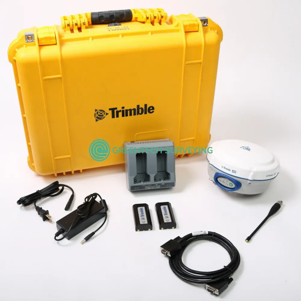
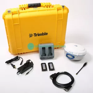
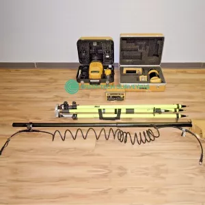
Package includes:
- 1x Trimble R6 Model 4 Receiver with GLONASS and UHF Transmit Enabled.
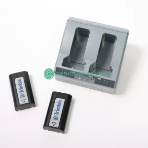
- 2x Trimble Li-Ion Rechargeable Batteries
- 1x Trimble Dual Battery Charger
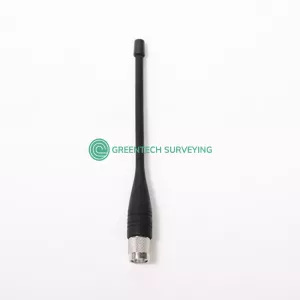
- 1x UHF Antenna
- 1x Rugged Transport Case
- 30-day money back guarantee
Measurement Performance
- Advanced Trimble Maxwell 6 Custom Survey GNSS chip with 220 channels
- Trimble R-Track technology
- High precision multiple correlator for GNSS pseudorange measurements
- Unfiltered, unsmoothed pseudorange measurements data for low noise, low multipath error, low time domain correlation and high dynamic response
- Very low noise GNSS carrier phase measurements with <1 mm precision in a 1 Hz bandwidth
- Signal-to-Noise ratios reported in dB-Hz
- Proven Trimble low elevation tracking technology
- Satellite signals tracked simultaneously:
- GPS: L1 C/A, L1C, L2C, L2E, L5
- GLONASS: L1 C/A, L1P, L2 C/A, L2P, L3 (optional)
- SBAS: QZSS, WAAS, EGNOS, GAGAN
- Galileo: E1, E5A, E5B (optional)
- BeiDou (COMPASS): B1, B2 (optional)
Trimble R6 Model 4 Key Features
- Trimble R-track technology
- Trimble Maxwell 6 Custom Survey GNSS chip with 220 channels
- Centimeter-accuracy, real-time positioning with RTK/OTF data, up to 10 Hz position updates
- Submeter-accuracy, real-time positioning using pseudorange corrections
- Automatic OTF (on-the-fly) initialization while moving
- Internal 450 MHz radio with a transmit option or GSM/GPRS options
Trimble R6 Model 4 Specifications
| HARDWARE | |
| Physical | |
| Dimensions (W x D) | 19.0 x 10.4 cm (7.5x x 4.1 in) deep including connectors |
| Weight | 1.52 kg (3.35 lbs) including internal battery, radio, and standard antenna |
| Temperature | Operating: –40 °C to +65 °C (–40 °F to +149 °F) |
| Storage: –40 °C to +75 °C (–40 °F to +167 °F) | |
| Humidity | 100% Condensing |
| Casing | Water/dustproof IP67 dustproof, protected from temporary immersion to depth of 1 m (3.28 ft) |
| Shock | Non-operating: Designed to survive a 2 m (6.6 ft) pole drop onto concrete. Operating: to 40 G, 10 msec, sawtooth |
| Vibration | MIL-STD-810F, FIG.514.5C-1 |
| Electrical | |
| Power | 11 V DC to 28 V DC external power input with over-voltage protection on Port 1 (7-pin Lemo) |
| Rechargeable | Removable 7.4 V, 2.6 Ah Lithium-Ion battery. |
| Power consumption | 3.2 W, in RTK rover mode with internal radio and Bluetooth in use. |
| Operating times on internal battery | 5.0 hours (450 MHz receive only option) |
| 2.5 hours (450 MHz receive/transmit option (0.5 W)) | |
| 4.7 hours (Cellular receive option) | |
| Communications and Data Storage | |
| Serial | 3-wire serial (7-pin Lemo) on Port 1; full RS-232 serial on Port 2 (Dsub 9 pin) |
| Radio modem | Fully Integrated, fully sealed internal 450 MHz receiver/transmitter option:
|
| Cellular | Fully integrated, sealed internal GSM/GPRS option |
| Bluetooth | Fully integrated, fully sealed 2.4 GHz communications port (Bluetooth®) |
| Data storage | 11 MB internal memory, 188.6 hours of raw observables (approx. 1.4 MB/day), based on recording every 15 seconds from an average of 14 satellites |
| Data formats | |
| CMR | CMR+, CMRx input and outputs |
| RTCM | RTCM 2.1, RTCM 2.3, RTCM 3.0, RTCM 3.1 input and outputs |
| Other outputs | 23 NMEA outputs, GSOF, RT17 and RT27 outputs, supports BINEX and smoothed carrier |
| Supported Trimble Controllers | Trimble TSC3 controller |
| Trimble CU controller | |
| Trimble Tablet Rugged PC | |
| Certifications | FCC Part 15 (Class B device), 22, 24, 90; CE Mark; C-Tick; 850/1900 MHz; Class 10 GSM/GPRS module; Bluetooth EPL |
| POSITIONING PERFORMANCE | |
| Code Differential GNSS Positioning | |
| Horizontal accuracy | 0.25 m + 1 ppm RMS |
| Vertical accuracy | 0.50 m + 1 ppm RMS |
| SBAS differential positioning | typically <5 m 3DRMS |
| STATIC GNSS SURVEYING | |
| High-precision static | |
| Horizontal accuracy | 3 mm + 0.1 ppm RMS |
| Vertical accuracy | 3.5 mm + 0.4 ppm RMS |
| Static and FastStatic | |
| Horizontal accuracy | 3 mm + 0.5 ppm RMS |
| Vertical accuracy | 5 mm + 0.5 ppm RMS |
| POSTPROCESSED KINETIC (PPK) GNS SURVEYING | |
| Horizontal accuracy | 8 mm + 1 ppm RMS |
| Vertical accuracy | 15 mm + 1 ppm RMS |
| REAL-TIME KINEMATIC SURVEYING | |
| Single Baseline <30 km | |
| Horizontal accuracy | 8 mm + 1 ppm RMS |
| Vertical accuracy | 15 mm + 1 ppm RMS |
| NETWORK RTK | |
| Horizontal accuracy | 8 mm + 0.5 ppm RMS |
| Vertical accuracy | 15 mm + 0.5 ppm RMS |
| Initialization time | typically <8 seconds |
| Initialization reliability | typically >99.9% |