


Description
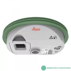
The Leica GS07 is Leica Geosystems’ mid-range GNSS smart antenna. It is the lightweight yet robust piece of equipment which comes with functionality focused on exactly what you need, with the highest quality levels one would expect from a premium Leica Geosystems GNSS portfolio.
The GS07 guarantees fast and reliable stake out and data capture combined in an easy-to-use rover with 320 channels, multi frequency and multi constellation. It also supports expansion of communication devices such as UHF radios which are fully integrated in the Leica CS20 field controller. Through its connectivity to Leica Captivate field software and the CS20, the GS07 delivers true Leica Geosystems quality.
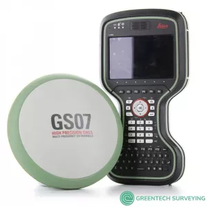
The GS07 is Leica's entry level GNSS RTK Network Rover. This package features a Leica GS07 320 channel GNSS receiver with GPS, Glonass, and Galileo constellations, coupled with a Leica CS20 data collector running Leica Captivate software with a full 5” color touch screen, GSM modem & WiFi.
The Leica GS07 is accompanied with the revolutionary Captivate software, turning complex data into the most realistic and workable 3D models. With easy-to-use apps and familiar touch technology, all forms of measured and design data can be viewed in all dimensions. Leica Captivate spans industries and applications with little more than a simple swipe, regardless of whether you work with GNSS, total stations or both.
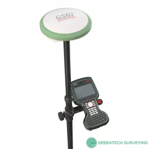
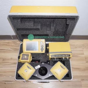
Leica GS07 GNSS NetRover Package sale with CS20 LTE Field Controller, Leica Captivate Measure & Stakeout, Leica Captivate Worksite+ (Ref Line / DTM Stake / Volume Calculation)
Package includes:
GNSS Antenna
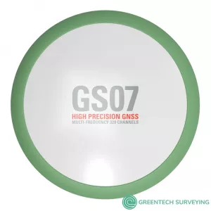
- Leica GS07 GNSS receiver
- LOP75 GS07 GLONASS Option
- 2X GEB212 Li-Ion Battery
- GVP734 GNSS Rover Container
Controller
- Leica CS20 LTE Field Controller
- 2X GEB334 Li-Ion Battery
- MSD1000 SD Memory Card 1GB
- GHT63 Pole Clamp
- GHT66 Holder Plate for CS20
Accessories
- GKL341 Charger
- GLS30 GNSS Telescopic Carbon-fibre Pole
Applications
- Leica Captivate Measure & Stakeout CS20
- Leica Captivate Worksite+ for CS20 (Ref Line / DTM Stake / Volume Calculation)
- 1 Year Leica Viva GNSS (GS0X+CS20) Basic CCP
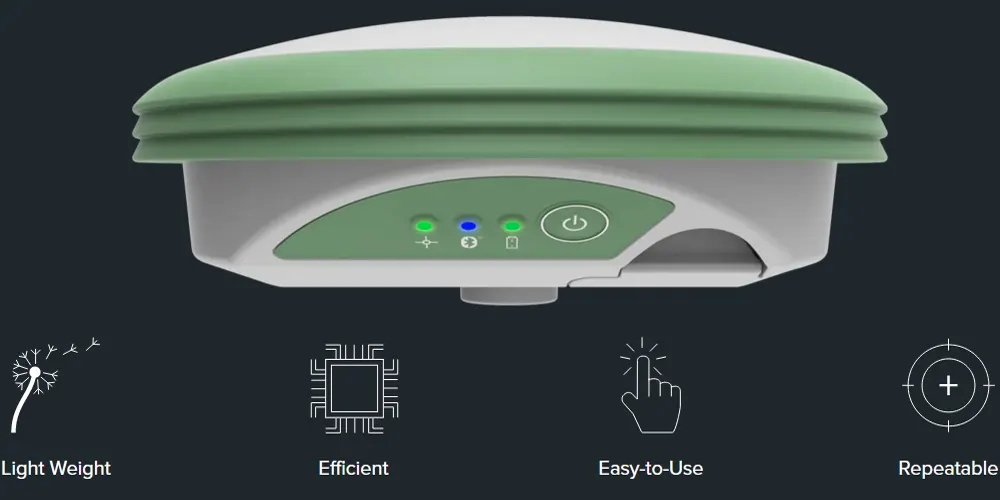
The Leica GS07 is robust, reliable, and easy-to-use. Streamlined to be one of the most efficient solutions, it holds its own against its bigger siblings. The GS07 was designed to deliver the slimmest and lightest form factor in a Smart Antenna.
- ENGAGING SOFTWARE: The GS07 GNSS RTK sensor combines seamlessly with the completely engaging Leica Captivate software for a powerfully immersive experience. Through the simplicity of touch, management of complex data is made extraordinarily enjoyable and actionable. Leica Captivate spans industries and applications with little more than a simple swipe, regardless of whether you work with GNSS, total stations or both.
- INFINITE POSSIBILITIES: While Captivate captures and models data in the field, Leica Infinity processes the information back in the office. A smooth data transfer ensures the project stays on track. Captivate and Infinity work in conjunction to join previous survey data and edit projects faster and more efficiently.
- POWERFUL HANDHELD DEVICES: Take your entire office on the go when you discover the power to overcome any environment from the palm of your hand. The Leica CS20 controller provides the ultimate in control and convenience with complete mobility. Touchscreen technology allows for comfortable and quick data processing while a stunning 3D view transforms your GNSS experience.
- CUSTOMER CARE AT A CLICK: Through Active Customer Care, a global network of experienced professionals is only a click away to expertly guide you through any problem.
- - Eliminate delays with superior technical service
- - Finish jobs faster with excellent consultancy report
- - Avoid costly site revisits with online service to send and receive data directly from the field. Control your costs with a tailored Customer Care Package, giving you peace of mind you’re covered anywhere, anytime.
AT 186MM X 71MM 1.5LBS THE LEICA GS07 EASILY FITS IN YOUR GLOVE BOX.

- 320 CHANNELS: With this amount of channels, you are able to track all known satellites delivering accurate results, period.
- SMART TRACK: Achieving total signal reliability is the key to delivering accurate and precise measurements. Our SmartTrack technology ensures that your antenna acquires and tracks a solid signal, even in dynamic environments.
- SMARTCHECK 99.95% Reliability: In a surveyor’s world, double and triple checking work is part of everyday life. Knowing that the measurements are correct is everything. By continuously validating your RTK, SmartCheck assures consistent measurements.
- IP68 AND MORE: Protect against water, sand, and dust on any job site. In addition, it can withstand extreme temperature (-40 to 65 C operating/-40 to 80 C storage) and can withstand a drop from more than 6 feet.
- TRY THE GS07: See if it works for you. We are pretty confident you won't want to give it back. Either get a demo or rent one today and test it on your next job.
- INSIGHTS: Be inspired by the success of other surveyors and discover how to maximize quality, efficiency and productivity.
- CAPTIVATE: Companies often can get lost in the race to add features while forgetting about the most important element, you. With Captivate, we focused on bringing back the human side to technology.
- LEICA ACTIVE ASSIST: Solve your problems in the field with the help of our support team that can remotely access your device and assist with any needs in the field.
- LEICA EXCHANGE: Easily and seamlessly sync your data with the office for an efficient and easy workflow.
LEICA GS07 CS20 GNSS NetRover TECHNICAL SPECIFICATIONS
| GNSS PERFORMANCE | ||
| GNSS Technology | Leica RTKplus | Adaptive on-the-fly satellite selection |
| Leica SmartCheck | Continuous check of RTK solution | Reliability 99.95% |
| Signal tracking | GPS | GLONASS | L1, L2, L2C, L5 | L1, L2, L2C, L3 |
| Galileo | BeiDou | E1, E5a, E5b, AltBOC, E6 | B1I, B1C, B2I, B2a, B3I | |
| QZSS | NavIC | L1, L2C, L5, L62 | L53 | |
| SBAS | WAAS, EGNOS, MSAS, GAGAN | |
| RAIM | Receiver Autonomous Integrity Monitoring | Detection and elimination of faulty satellite signals for enhanced positioning solution and GNSS integrity |
| Number of channels | 320 hardware channel | |
| MEASUREMENT PERFORMANCE & ACCURACY | ||
| Time for initialisation | Typically 6 s | |
| Real-time kinematic (Compliant to IS017123-8 standard) |
Single baseline Network RTK |
Hz 10 mm + 1 ppm / V 20 mm + 1 ppm Hz 10 mm + 0.5 ppm / V 20 mm + 0.5 ppm |
| Post processing | Static (phase) with long observations Static and rapid static (phase |
Hz 3 mm + 0.5 ppm / V 6 mm + 0.5 ppm Hz 5 mm + 0.5 ppm / V 10 mm + 0.5 ppm |
| Code differential | DGNSS | Hz 25 cm | V 50 cm |
| COMMUNICATIONS | ||
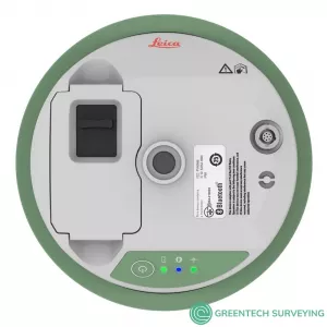
| Communication ports | Lemo Bluetooth® |
USB and RS232 serial Bluetooth v2.00 + EDR, class 2 |
| Communication protocols | RTK data protocols Network RTK |
Leica, Leica 4G, CMR, CMR+, RTCM 2.2, 2.3, 3.0, 3.1, 3.2 MSM VRS, FKP, iMAX, MAC (RTCM SC 104) |
| Built-in data links 4 | 3.75G GSM / UMTS / CDMA phone modem Radio modem |
Fully integrated, internal antenna Fully integrated, receive, external antenna 403 - 473 MHz, up to 28800 bps over air |
| External data links | Bluetooth GSM / GPRS / UMTS / LTE / CDMA phone modem | |
| GENERAL | ||
| Field controller and software | Leica Captivate software | Leica CS20 field controlle |
| User interface | Buttons and LEDs | On / Off button, 3 status LEDs |
| Data recording | Storage 5 Data type and recording rate |
Removable SD card Leica GNSS raw data and RINEX data at up to 5 Hz |
| Power management | Internal power supply External power supply Operation time 6 |
Exchangeable Li-Ion battery (2.6 Ah / 7.4 V) Nominal 12 V DC, range 10.5 - 28 V DC 8 h GNSS 7 h receiving RTK data with CS modem |
| Weight and dimensions | Weight Diameter x Height |
0.7 kg / 2.7 kg standard RTK rover setup on pole 186 mm x 71 mm |
| Environmental | Temperature Drop Proof against water, sand and dust Vibration Humidity Functional shock |
-40 to 65°C operating, -40 to 80°C storage Withstands topple over from a 2 m survey pole onto hard surfaces IP66 / IP68 (IEC60529 / MIL STD 810G CHG-1 510.6 I / MIL STD 810G CHG-1 506.6 II / MIL STD 810G CHG-1 512.6 I) Withstands strong vibration (ISO9022-36-05 / MIL STD 810G 514.6 Cat.24) 95% (ISO9022-13-06 / ISO9022-12-04 / MIL STD 810G CHG-1 507.6 II) 40 g / 15 to 23 msec (MIL STD 810G 516.6 I |
| LEICA GS07 – GNSS SMART ANTENNA | |||||
| SUPPORTED GNSS SYSTEMS | |||||
| Multi-frequency | Standard | ||||
| GPS / GLONASS / Galileo / BeiDou / QZSS | Standard / Optional / Optional / Optional / Standard | ||||
| RTK PERFORMANCE | |||||
| DGPS/RTCM, RTK Unlimited, Network RTK | Standard | ||||
| POSITION UPDATE & DATA RECORDING | |||||
| 5 Hz positioning | Standard | ||||
| Raw data / RINEX data logging | Standard / Standard | ||||
| ADDITIONAL FEATURES | |||||
| 3.75G GSM / GPRS / UMTS / CDMA phone modeM | Optional | ||||
| UHF radio modem (receive only) | Optional | ||||