

Description
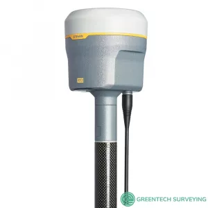
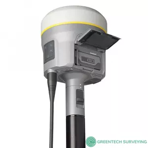
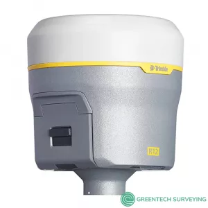
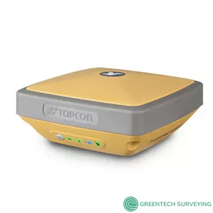
Trimble R12 GNSS Receiver System | Push the boundaries of GNSS performance, 8 mm H/15 mm V Max. Precision, 672 Channels, Integrated Antenna, UHF Radio Receive & Transmit
The Trimble R12 GNSS receiver is engineered for improved performance in challenging GNSS conditions. With ground-breaking signal management and rugged durability, get ready to go further than you ever thought possible. The Trimble R12 GNSS system is a high-performance solution for professional land surveyors that pushes the boundaries of what a GNSS receiver can do. Engineered for improved accuracy and productivity in challenging GNSS conditions. Powered by the all-new Trimble ProPoint™ GNSS engine, you can now collect data more accurately in challenging GNSS environments than was previously possible.
KEY FEATURES:
- Constellation agnostic, flexible signal tracking and improved positioning in challenging environments with Trimble ProPoint™ GNSS Technology
- ncreased measurement productivity and traceability with Trimble SurePoint eBubble tilt compensation
- Advanced Trimble Custom Survey GNSS chips with 672 channels
- Reduced downtime due to loss of radio signal or cellular connectivity with Trimble xFill technology
- Signals tracked simultaneously
- Android™ and iOS platform support
- Cellular, Bluetooth®, Wi-Fi data connectivity
- Military-spec rugged design and IP-67 rating
- Ergonomic form factor
- All day battery with built-in status indicator
- 6 GB internal memory
GAME-CHANGING TECHNOLOGIES
- ProPoint icon Trimble ProPoint GNSS Technology: Improved performance in challenging GNSS conditions*, with ground-breaking signal management that leverages the latest developments in GNSS signal infrastructure and Trimble receiver hardware
- SurePoint icon Trimble SurePoint Technology: Precise position capture with eBubble and compass-based tilt compensation
- Trimble 360 icon Trimble 360 Technology: 672 channels with support for all available and future GNSS signals, and improved protection from spoofed signals
- Trimble xFill icon Trimble xFill Technology: Keeps you working in radio and cellular black spots with continuous RTK coverage
- CenterPoint RTX Correction Service: Provides RTK level precision worldwide without the need for a base station or VRS network
POWERED BY TRIMBLE PROPOINT
- Better RTK and Trimble RTX performance near canopy: Increased accuracy, reliability and productivity near tree canopy
- Robust performance in urban environments: Advanced signal filtering and error modelling provide better protection against jamming and multipath
- Flexible signal management: Survey-grade positioning using most combinations of GNSS constellations and signals
- More signals, more satellites: Advanced tracking and GNSS signal management means superior RTK and Trimble RTX positioning in more places
UNMATCHED GNSS PERFORMANCE
- ProPoint GNSS delivers more than thirty percent** better performance in challenging environments
- Accurate: A precise solution for repeatable results
- Reliable: Real time error estimates in Trimble Access that empower the surveyor
- Productive: Faster convergence means less time spent measuring points in the field.
Create the complete Trimble R12 Solution
Pair with Trimble Access 2019 software and Trimble TSC7 controller. Trimble T10 or T7 tablets for a powerful rover solution in the field. Integrates seamlessly with the Trimble SX10 scanning total station and Trimble S-series total station positioning sensors. Process your data with Trimble Business Center and create high-quality deliverables with confidence
| TRIMBLE R12 GNSS RECEIVER TECHNICAL SPECIFICATION | ||
| TRIMBLE R12 GNSS RECEIVER | ||
| Constellation agnostic, flexible signal tracking and improved positioning1 in challenging environments with Trimble ProPoint GNSS technology | ||
| Increased measurement productivity and traceability with Trimble SurePoint eBubble tilt compensation | ||
| Advanced Trimble Custom Survey GNSS chips with 672 channels | ||
| Reduced downtime due to loss of radio signal or cellular connectivity with Trimble xFill technology | ||
| Signals tracked simultaneously | ||
| GPS: L1C, L1C/A, L2C, L2E, L5 GLONASS: L1C/A, L1P, L2C/A, L2P, L3 SBAS (WAAS, EGNOS, GAGAN, MSAS): L1C/A, L5 Galileo: E1, E5A, E5B, E5 AltBOC, E62 BeiDou: B1, B1C, B2, B2A, B3 QZSS: L1C/A, L1S, L1C, L2C, L5, L6 NavIC (IRNSS): L5 L-band: CenterPoint RTX |
||
| Iridium filtering above 1616 MHz allows antenna to be used up to 20 m away from iridium transmitter | ||
| Japanese LTE filtering below 1510 MHz allows antenna to be used up to 100 m away from Japanese LTE cell tower | ||
| Digital Signal Processor (DSP) techniques to detect and recover from spoofed GNSS signals | ||
| Advanced Receiver Autonomous Integrity Monitoring (RAIM) algorithm to detect and reject problem satellite measurements to improve position quality |
||
| Improved protection from erroneous ephemeris data | ||
| Positioning Rates | 1 Hz, 2 Hz, 5 Hz, 10 Hz, and 20 Hz | |
| POSITIONING PERFORMANCE | ||
| CODE DIFFERENTIAL GNSS POSITIONING | ||
| Horizontal | 0.25 m + 1 ppm RMS | |
| Vertical | 0.50 m + 1 ppm RMS | |
| SBAS | typically <5 m 3DRMS | |
| STATIC GNSS SURVEYING | ||
| High-Precision Static | ||
| Horizontal | 3 mm + 0.1 ppm RMS | |
| Vertical | 3.5 mm + 0.4 ppm RMS | |
| Static and Fast Static | ||
| Horizontal | 3 mm + 0.5 ppm RMS | |
| Vertical | 5 mm + 0.5 ppm RMS | |
| REAL TIME KINEMATIC SURVEYING | ||
| Single Baseline <30 km | ||
| Horizontal | 8 mm + 1 ppm RMS | |
| Vertical | 15 mm + 1 ppm RMS | |
| Network RTK | ||
| Horizontal | 8 mm + 0.5 ppm RMS | |
| Vertical | 15 mm + 0.5 ppm RMS | |
| RTK start-up time for specified precisions | 2 to 8 seconds | |
| TRIMBLE RTX™ TECHNOLOGY (SATELLITE AND CELLULAR/INTERNET (IP)) | ||
| CenterPoint RTX | ||
| Horizontal | 2 cm RMS | |
| Vertical | 5 cm RMS | |
| RTX convergence time for specified precisions - Worldwide | < 15 min | |
| RTX QuickStart convergence time for specified precisions | < 1 min | |
| RTX convergence time for specified precisions in select regions (Trimble RTX Fast Regions | < 1 min | |
| TRIMBLE XFILL | ||
| Horizontal | RTK9 + 10 mm/minute RMS | |
| Vertical | RTK9 + 20 mm/minute RMS | |
| HARDWARE | ||
| PHYSICAL | ||
| Dimensions (W×H) | 11.9 cm x 13.6 cm (4.6 in x 5.4 in) | |
| Weight | 1.12 kg (2.49 lb) with internal battery, internal radio with UHF antenna, 3.95 kg (8.71 lb) items above plus range pole, Trimble TSC7 controller & bracket |
|
| Temperature | ||
| Operating | –40 °C to +65 °C (–40 °F to +149 °F) | |
| Storage | –40 °C to +75 °C (–40 °F to +167 °F) | |
| Humidity | 100%, condensing | |
| Ingress protection | IP67 dustproof, protected from temporary immersion to depth of 1 m (3.28 ft) | |
| Shock and vibration (Tested and meets the following environmental standards) | ||
| Shock | Non-operating: Designed to survive a 2 m (6.6 ft) pole drop onto concrete. Operating: to 40 G, 10 msec, sawtooth |
|
| Vibration | MIL-STD-810F, FIG.514.5C-1 | |
| ELECTRICAL | ||
| Power 11 to 24 V DC external power input with over-voltage protection on Port 1 and Port 2 (7-pin Lemo) Rechargeable, removable 7.4 V, 3.7 Ah Lithium-ion smart battery with LED status indicators Power consumption is 4.2 W in RTK rover mode with internal radio11 |
||
| Operating times on internal battery | ||
| 450 MHz receive only option | 6.5 hours | |
| 450 MHz receive/transmit option (0.5 W) | 6.0 hours | |
| 450 MHz receive/transmit option (2.0 W) | 5.5 hours | |
| Cellular receive option | 6.5 hours | |
| COMMUNICATIONS AND DATA STORAGE | ||
| Serial | 3-wire serial (7-pin Lemo) | |
| USB v2.0 | Supports data download and high speed communications | |
| Radio modem | Fully Integrated, sealed 450 MHz wide band receiver/transmitter with frequency range of 403 MHz to 473 MHz, support of Trimble, Pacific Crest, and SATEL radio protocols: |
|
| Transmit power | 2 W | |
| Range | 3–5 km typical / 10 km optimal | |
| Cellular | Integrated, 3.5 G modem, HSDPA 7.2 Mbps (download), GPRS multi-slot class 12, EDGE multi-slot class 12, Penta-band UMTS/HSDPA (WCDMA/FDD) 800/850/900/1900/2100 MHz, Quad-band EGSM 850/900/1800/1900 MHz, GSM CSD, 3GPP LTE |
|
| Bluetooth | Version 4.115 | |
| Wi-Fi | 802.11 b,g, access point and client mode, WPA/WPA2/WEP64/WEP128 encryption | |
| I/O ports | Serial, USB, TCP/IP, IBSS/NTRIP, Bluetooth | |
| Data storage | 6 GB internal memory | |
| Data format | CMR+, CMRx, RTCM 2.1, RTCM 2.3, RTCM 3.0, RTCM 3.1, RTCM 3.2 input and output | |
| 24 NMEA outputs, GSOF, RT17 and RT27 outputs, 1 PPS output | ||
| WEBUI | ||
| Offers simple configuration, operation, status, and data transfer | ||
| Accessible via Wi-Fi, Serial, USB, and Bluetooth | ||
| SUPPORTED CONTROLLERS & FIELD SOFTWARE | ||
| Trimble TSC7, Trimble T10, Trimble T7, Android and iOS devices running supported apps | ||
| Trimble Access 2019.10 or later | ||
| CERTIFICATIONS | ||
| FCC Part 15 (Class B device), 24, 32; CE Mark; RCM; PTCRB; BT SIG | ||
TRIMBLE R12 GNSS SYSTEM WITH TRIMBLE TSC7 CONTOLLER
 1. Challenging GNSS environments are locations where the receiver has sufficient satellite availability to achieve minimum accuracy requirements, but where the signal may be partly obstructed by and/or reflected off of trees, buildings, and other objects. Actual results may vary based on user’s geographic location and atmospheric activity, scintillation levels, GNSS constellation health and availability, and level of multipath and signal occlusion.
- 2. The current capability in the receivers is based on publicly available information. As such, Trimble cannot guarantee that these receivers will be fully compatible with a future generation of Galileo satellites or signals.
- 3. Precision and reliability may be subject to anomalies due to multipath, obstructions, satellite geometry, and atmospheric conditions. The specifications stated recommend the use of stable mounts in an open sky view, EMI and multipath clean environment, optimal GNSS constellation configurations, along with the use of survey practices that are generally accepted for performing the highest-order surveys for the applicable application including occupation times appropriate for baseline length. Baselines longer than 30 km require precise ephemeris and occupations up to 24 hours may be required to achieve the high precision static specification.
- 4. Depends on SBAS system performance.
- 5. Network RTK PPM values are referenced to the closest physical base station.
- 6. May be affected by atmospheric conditions, signal multipath, obstructions and satellite geometry. Initialization reliability is continuously monitored to ensure highest quality.
- 7. RMS performance based on repeatable in field measurements. Achievable accuracy and initialization time may vary based on type and capability of receiver and antenna, user’s geographic location and atmospheric activity, scintillation levels, GNSS constellation health and availability and level of multipath including obstructions such as large trees and buildings.
- 8. Accuracies are dependent on GNSS satellite availability. xFill positioning without a Trimble CenterPoint RTX subscription ends after 5 minutes of radio downtime. xFill positioning with a CenterPoint RTX subscription will continue beyond 5 minutes providing the Trimble RTX solution has converged, with typical precisions not exceeding 6 cm horizontal, 14 cm vertical or 3 cm horizontal, 7 cm vertical in Trimble RTX Fast regions. xFill is not available in all regions, check with your local sales representative for more information.
- 9. RTK refers to the last reported precision before the correction source was lost and xFill started.
- 10. Receiver will operate normally to –40 °C, internal batteries are rated from –20 °C to +60 °C (ambient +50 °C).
- 11. Tracking GPS, GLONASS and SBAS satellites.
- 12. Varies with temperature and wireless data rate. When using a receiver and internal radio in the transmit mode, it is recommended that an external 6 Ah or higher battery is used.
- 13. Varies with terrain and operating conditions.
- 14. Due to local regulations, the integrated cellular modem cannot be enabled in China, Taiwan, or Brazil. A Trimble controller integrated cellular modem or external cellular modem can be used to obtain GNSS corrections via an IP (Internet Protocol) connection.
- 15. Bluetooth type approvals are country specific.
Documentations