
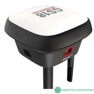
Description
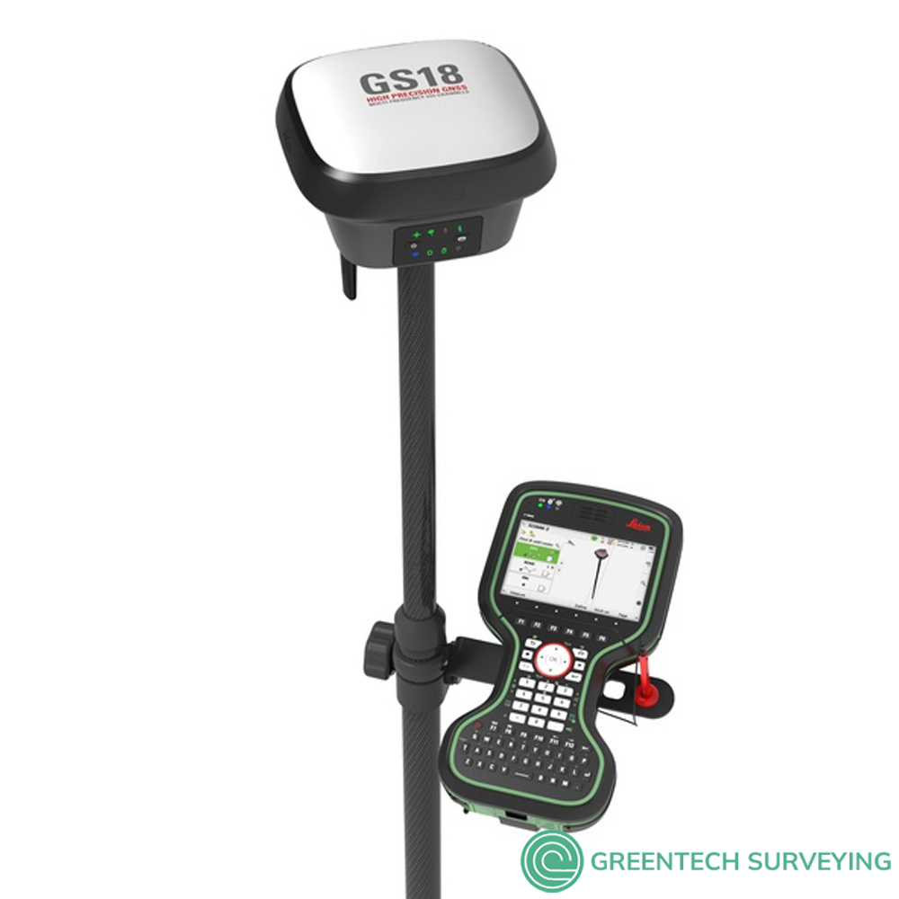
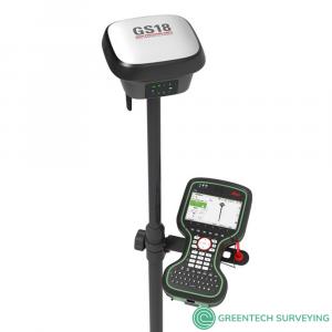
Leica GS18 T GNSS RTK Rover, the original tilt compensating GNSS RTK rover
The Leica GS18 T GNSS RTK Rover is the fastest and easiest-to-use GNSS smart antenna and RTK rover because you save time by no longer needing to hold the pole vertical to level the bubble. This latest innovation, with industry-leading technology, combines GNSS and inertial measurement units (IMUs) to be the first true tilt compensation solution immune to magnetic disturbances and it is calibration-free.
As you no longer need to watch and level the bubble, you can focus on your task at hand and save time over conventional surveying practices. Uninterrupted, accurate positioning when surrounded by or in close proximity to metallic objects - measure where others simply couldn’t before. The GS18 T works directly out of the box without any calibration procedure.
Package includes:
- Leica GS18 T LTE & UHF Performance SmartAntenna
- LOP60 GLONASS option
- LOP61 Galileo option
- GAT28 UHF radio antenna 403-473MHz
- GEB331 Li-Ion battery (2)
- GKL311 Single battery charger (2)
- MSD1000 SD memory card 1GB
- GAT27 Multiband LTE antenna
- GVP734 carry case
- Leica CS20 LTE Field Controller
- Leica Captivate Software - Measure & Stakeout
- GLS30 rover pole & brackets
- 1 Year CCP Bronze (Customer Care Package)
The new Leica GS18 T intelligently engineered tilt technology completely eliminates the need to stop and level up. Giving you a radical increase in speed and the ability to measure points that previously were very challenging. The Leica GS18 GNSS S RTK Rover without tilt technology can upgraded to a tilt compensating rover any time by the Leica Geosystems service
- SELF-LEARNING: The new RTK Plus technology allows for adaptive on-the-fly satellite selection, learning which signals are valid, invalid, or bounced from nearby buildings. This helps overcome challenging situations typical antenna may not succeed in.
- 555: With 555 channels at its disposal, the GS18 T measurement engine supports all known signals and identifies their optimal combination.
- SMARTLINK: SmartLink shines in difficult scenarios where getting RTK corrections seems impossible. Combining L-band signals with GNSS satellites, SmartLink is able to deliver corrections under the most challenging scenarios, such as deep gorges, and remote areas.
- SMARTCHECK 99.99% Reliability: In a surveyor’s world, double and triple checking work is part of everyday life. Knowing that the measurements are correct is everything. By continuously validating your RTK, SmartCheck assures consistent measurements.
- IP68: A.K.A. Fear No Element: You can pretty much expose the GS18 T to extreme heat and cold, dust and water, accidental drops, and even use it as a paddle when canoeing...we have.
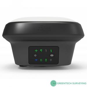
- FUNCTIONAL DESIGN: Packed with features the Leica GS18 T team went beyond the circuit boards, and carefully considered every aspect of the design. With its square format, leaning the SmartAntenna against your truck, or other places like walls and fences, has become now much easier.
- Insights: Be inspired by the success of other surveyors and discover how to maximize quality, efficiency and productivity.
- CAPTIVATE: Companies often can get lost in the race to add features while forgetting about the most important element, you. With Captivate, we focused on bringing back the human side to technology.
- LEICA ACTIVE ASSIST: Solve your problems in the field with the help of our support team that can remotely access your device and assist with any needs in the field
- LEICA EXCHANGE: Easily and seamlessly sync your data with the office for an efficient and easy workflow.
LEICA GS18 T GNSS RTK ROVER DATA SHEET
- Engaging software: Leica Captivate field software is the perfect companion for the GS18 T. Everything from measuring, viewing, and sharing data is done within one software. Easy-to-use apps and precise 2D views/3D models enable you to understand, create and utilise data effectively. Captivate spans industries and project use cases with little more than a simple tap, regardless of whether you work with GNSS, total stations or both.
- Seamlessly share data among all your instruments: Leica Infinity imports and combines data from your GNSS RTK rover, total station, level instruments and laser scanners for one final and accurate result. Processing has never been easier because all your instruments work in tandem to produce precise and actionable information.
- Customer care only a click away: Through Active Customer Care (ACC), a global network of experienced professionals is only a click away to expertly guide you through any challenge. Eliminate delays with superior technical service, finish jobs faster and avoid costly site revisits with excellent consultancy support. Control your costs with a tailored Customer Care Package (CCP), giving you peace of mind you are covered anywhere, anytime.
| LEICA GS18 T GNSS SMART ANTENNA RTK ROVER TECHNICAL SPECIFICATIONS | ||
| GNSS TECHNOLOGY & SERVICES | ||
| Self-learning GNSS | Leica RTKplus | Adaptive on-the-fly satellite selection |
| HxGN SmartNet Global | HxGN SmartNet Pro | Network RTK and unlimited worldwide RTK bridging and PPP service |
| HxGN SmartNet+ | Network RTK and RTK bridging service | |
| HxGN SmartNet PPP | Unlimited worldwide RTK bridging and PPP service | |
| Leica SmartCheck | ontinuous check of RTK solution | Reliability 99.99% |
| Signal tracking | GPS | GLONASS | L1, L2, L2C, L5 | L1, L2, L2C, L3 |
| Galileo | BeiDou | E1, E5a, E5b, AltBOC, E6 | B1I, B1C, B2I, B2a, B3I | |
| QZSS | NavIC | L1, L2C, L5, L62 | L53 | |
| SBAS | TerraStar | WAAS, EGNOS, MSAS, GAGAN | L-Band, IP | |
| RAIM | Receiver Autonomous Integrity Monitoring | Detection and elimination of faulty satellite signals for enhanced positioning solution and GNSS integrity |
| Number of channels | 555 (more signals, fast acquisition, high sensitivity) | |
| Tilt compensation | Increased measurement productivity and traceability | Calibration-free Immune to magnetic disturbances |
| MEASUREMENT PERFORMANCE & ACCURACY | ||
| Time for RTK initialisation | Typically 4 s | |
| Real-time kinematic (Compliant to ISO17123-8 standard) |
Single baseline Network RTK |
Hz 8 mm + 1 ppm | V 15 mm + 1 ppm Hz 8 mm + 0.5 ppm | V 15 mm + 0.5 ppm |
| Real-time kinematic tilt compensated | Not for static control points | Additional Hz uncertainty max 8 mm + 0.4 mm/° tilt down to 30° tilt |
| RTK bridging | Up to 10 min bridging of RTK outages | Hz 2.5 cm | V 5 cm |
| PPP | Initial convergence to full accuracy typically 10 min, Re-convergence < 1 min |
Hz 2.5 cm | V 5 cm |
| Post processing | Static (phase) with long observations Static and rapid static (phase) |
Hz 3 mm + 0.1 ppm | V 3.5 mm + 0.4 ppm Hz 3 mm + 0.5 ppm | V 5 mm + 0.5 ppm |
| Code differential | DGNSS | Hz 25 cm | V 50 cm |
| Image point measurement | 1-click measurement in field & office | Typically 2 cm – 4 cm (2D1) captured from 2 – 10 m distance |
| COMMUNICATIONS | ||
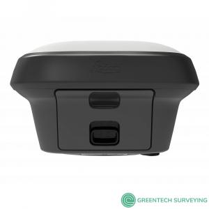
| Communication ports | Lemo | Bluetooth® | WLAN | USB and RS232 serial | Bluetooth® v4.0 (BLE & BR/EDR), class 1.5 | 802.11 b/g/n for field controller communication only |
| Communication protocols | RTK data protocols NMEA output Network RTK |
Leica 4G, Leica, CMR, CMR+, RTCM 2.2, 2.3., 3.0, 3.1, 3.2 MSM NMEA 0183 v4.00 & v4.10 and Leica proprietary VRS, FKP, iMAX, MAC (RTCM SC 104) |
| Built-in 4G LTE modem4 | LTE frequency bands UMTS frequency bands GSM frequency bands |
20, 8, 3, 1, 7 | 13, 17, 5, 4, 2 | 19, 3, 1 8, 3, 1 | 5, 4, 2 | 6, 19, 1 900, 1800 | 850, 900, 1800, 1900 MHz |
| Built-in UHF modem5 | Receive & transmit UHF radio modem | 403 – 473 MHz, channel spacing 12.5 kHz, 20 kHz, 25 kHz, max. 1 W output power up to 28800 bps over air | 902 – 928 MHz (licence free in North America), max 1 W output power |
| GENERAL | ||
| Field controller and software | Leica Captivate software | Leica CS20 LTE or BASIC field controller, Leica CS30 & CS35 tablets |
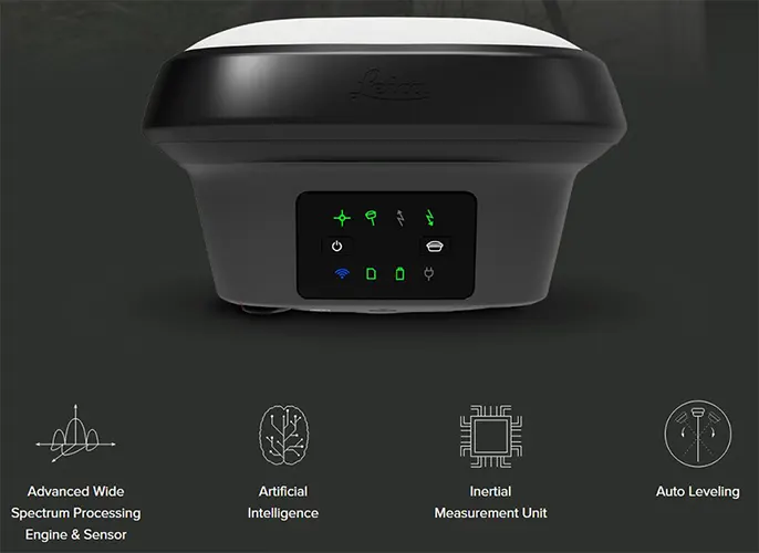
| User interface | Buttons and LEDs Web server |
On / Off and Function button, 8 status LEDs Full status information and configuration options |
| Data recording | Storage Data type and recording rate |
Internal memory up to 4 GB, Removable SD card Leica GNSS raw data and RINEX data at up to 20 Hz |
| Power management | Internal power supply External power supply Operating time6 |
IExchangeable Li-Ion battery (2.8 Ah / 11.1 V) Nominal 12 V DC, range 10.5 – 26.4 V DC Typical time up to 8 h |
| Weight and dimensions | Weight | Dimensions | 1.25 kg / 3.55 kg standard RTK rover setup on pole | 173 mm x 173 mm x 109 mm |
| Environmental | Temperature Drop Proof against water, sand and dust Vibration Humidity Functional shock |
-30 to +50°C operating with camera, -40 to +65°C operating without camera, -40 to +85°C storage Withstands topple over from a 2 m survey pole onto hard surfaces IP66 | IP68 (IEC60529 | MIL STD 810G CHG-1 510.6 I | MIL STD 810G CHG-1 506.6 II, MIL STD 810G CHG-1 512.6 I) Withstands strong vibration (ISO9022-36-08 | MIL STD 810G 514.6 Cat.24) 95% (ISO9022-13-06 | ISO9022-12-04 | MIL STD 810G CHG-1 507.6 II) 40 g / 15 to 23 msec (MIL STD 810G 516.6 I) |
| LEICA GS18 T GNSS RTK ROVER | PERFORMANCE | UNLIMITED |
|
SUPPORTED GNSS SYSTEMS
|
|
|
|
RTK PERFORMANCE
|
|
|
|
POSITION UPDATE & DATA RECORDING
|
|
|
|
ADDITIONAL FEATURES
|
|
|
| LEICA GEOSYSTEMS GNSS COMPARISON CHART | |||||||||||||||||||||||||||||||||||||||||
 |
 |
 |
 |
 |
 |
||||||||||||||||||||||||||||||||||||
| Signal tracking |
Dual-frequency
|
Dual-frequency
|
Multi-frequency
|
Multi-frequency
|
Multi-frequency
|
Multi-frequency
|
|||||||||||||||||||||||||||||||||||
|
|
|
|
|
|
|
|||||||||||||||||||||||||||||||||||
|
|
|
|
|
|
|
|||||||||||||||||||||||||||||||||||
| Tilt compensation |
 |
|
|
 |
|
|
|||||||||||||||||||||||||||||||||||
| Single baseline RTK |
Hz 10 mm + 1 ppm / V 20 mm + 1 ppm
|
Hz 8 mm + 1 ppm / V 15 mm + 1 ppm
|
Hz 8 mm + 1 ppm / V 15 mm + 1 ppm
|
Hz 8 mm + 1 ppm / V 15 mm + 1 ppm
|
Hz 8 mm + 1 ppm / V 15 mm + 1 ppm
|
Hz 8 mm + 1 ppm / V 15 mm + 1 ppm
|
|||||||||||||||||||||||||||||||||||
| Network RTK |
Hz 10 mm + 0.5 ppm / V 20 mm + 0.5 ppm
|
Hz 8 mm + 0.5 ppm / V 15 mm + 0.5 ppm
|
Hz 8 mm + 0.5 ppm / V 15 mm + 0.5 ppm
|
Hz 8 mm + 0.5 ppm / V 15 mm + 0.5 ppm
|
Hz 8 mm + 0.5 ppm / V 15 mm + 0.5 ppm
|
Hz 8 mm + 0.5 ppm / V 15 mm + 0.5 ppm
|
|||||||||||||||||||||||||||||||||||
| Static (phase) with long observations |
Hz 3 mm + 0.5 ppm / V 6 mm + 0.5 ppm
|
Hz 3 mm + 0.1 ppm / V 3.5 mm + 0.4 ppm
|
Hz 3 mm + 0.1 ppm / V 3.5 mm + 0.4 ppm
|
Hz 3 mm + 0.1 ppm / V 3.5 mm + 0.4 ppm
|
Hz 3 mm + 0.1 ppm / V 3.5 mm + 0.4 ppm
|
Hz 3 mm + 0.1 ppm / V 3.5 mm + 0.4 ppm
|
|||||||||||||||||||||||||||||||||||
| Static and rapid static (phase) |
Hz 5 mm + 0.5 ppm / V 10 mm + 0.5 ppm
|
Hz 3 mm + 0.5 ppm / V 5 mm + 0.5 ppm
|
Hz 3 mm + 0.5 ppm / V 5 mm + 0.5 ppm
|
Hz 3 mm + 0.5 ppm / V 5 mm + 0.5 ppm
|
Hz 3 mm + 0.5 ppm / V 5 mm + 0.5 ppm
|
Hz 3 mm + 0.5 ppm / V 5 mm + 0.5 ppm
|
|||||||||||||||||||||||||||||||||||
| Reliability |
99,95%
|
99,95%
|
99,95%
|
99,95%
|
99,95%
|
99,95%
|
|||||||||||||||||||||||||||||||||||
|
|
|
|
|
|
|
|||||||||||||||||||||||||||||||||||
|
|
|
|
|
|
|
|||||||||||||||||||||||||||||||||||
| RTK reference station functionality |
|
|
|
|
|
|
|||||||||||||||||||||||||||||||||||
| Cellular / UHF Radio (receive & transmit) modem |
Controller internal
|
3G
|
3G
|
4G
|
3G
|
3G
|
|||||||||||||||||||||||||||||||||||
| Storage |
Controller internal
|
MicroSD card
|
MicroSD card
|
SD card
|
SD card
|
SD card
|
|||||||||||||||||||||||||||||||||||
|
|
|
|
|
|
|
|||||||||||||||||||||||||||||||||||
| Power, Bluetooth®, USB, RS232 |
|
|
|
|
|
|
|||||||||||||||||||||||||||||||||||
| Event, PPS |
|
|
|
|
|
|
|||||||||||||||||||||||||||||||||||
| Operating temperature -40°C to 65°C |
|
|
|
|
|
|
|||||||||||||||||||||||||||||||||||
| IP68 proof against water, sand and dust |
|
|
|
|
|
|
|||||||||||||||||||||||||||||||||||
| Weight (without battery) |
0.60 kg
|
0.93 kg
|
0.93 kg
|
1.20 kg
|
1.20 kg
|
1.84 kg
|
|||||||||||||||||||||||||||||||||||
Download